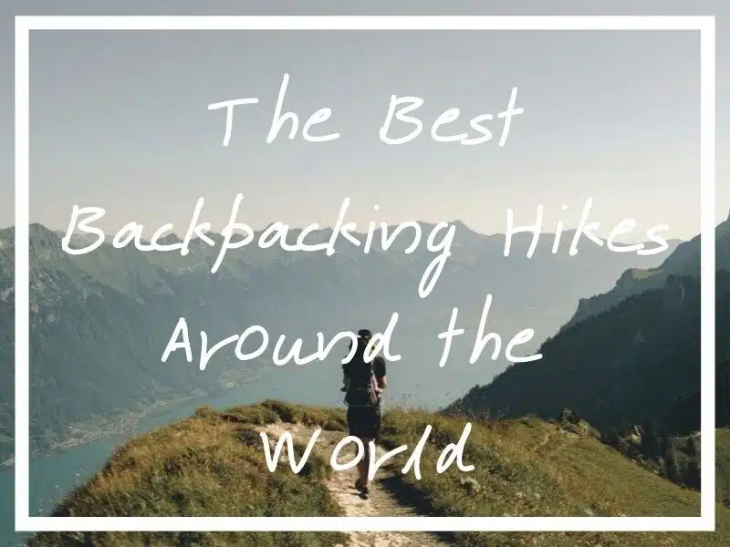
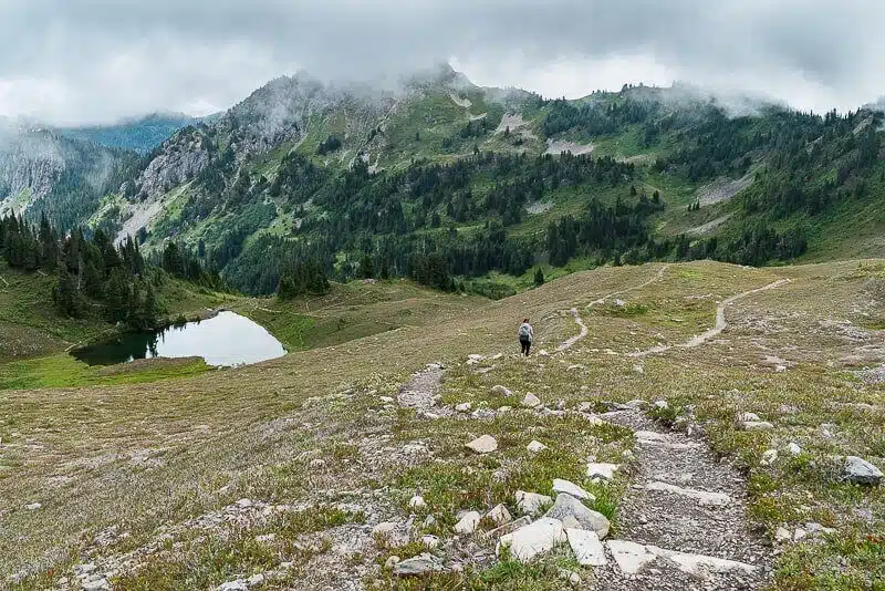
I hope any hikers out there find real value in this epic list of the world’s best backpacking hikes.
You can’t beat a good hike.
Everything from the hard physical graft in the great outdoors to the stunning scenery makes it a deeply gratifying endeavour.
Thankfully, the world’s full of epic hiking and trekking opportunities. There’s a trail for every occasion, no matter the country you’re exploring.
That’s good news for backpackers, like me, who love the chance to stretch their legs on the road!
It got me wondering about all the best backpacking hikes out there.
To discover more, I asked a bunch of fellow travel and hiking enthusiasts for recommendations, based on their personal experiences.
I ended up with one awesome list of hikes in countries across the globe! There’s truly a walk for everyone, everywhere.
The following post should prove an invaluable resource for any hiker looking to find their next trail. Sound good?
Keep reading to discover a wide-ranging selection of the best hikes around the world.
The Best Hikes in Europe
Let’s start with the best hikes in Europe. Here are some epic treks to do all over this sprawling continent. Enjoy!
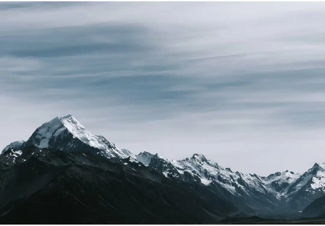
1. Hardergrat Trail, Switzerland
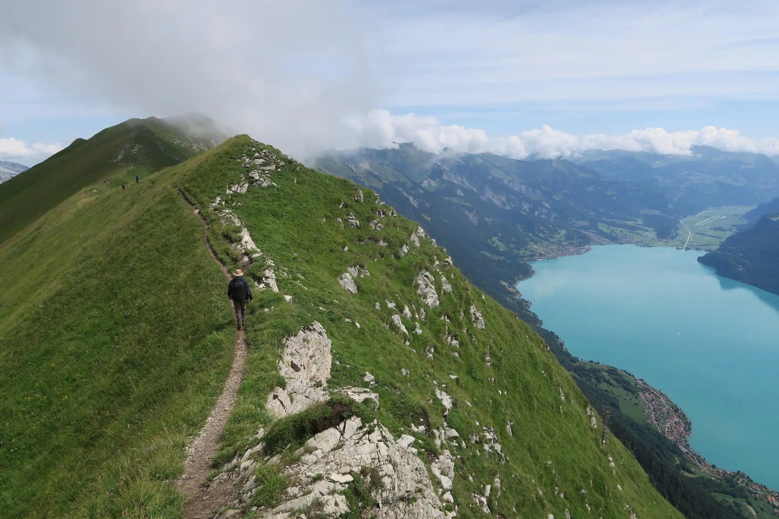
The Hardegrat Trail in Switzerland is one of the best hikes in Europe. Look at those views!
- Location: Switzerland
- Distance: 24km
- Duration: All Day
- Difficulty: Moderate to Hard
A classic hike in Switzerland among hikers and trail runners is the Hardergrat trail.
It is a 24 km ridge hike, starting from Interlaken. You will have to conquer the 3000 m elevation gain.
That’s a lot of up and down hiking in one day.
You will need to set off early in the morning in order to complete the whole hike and catch the last train down from Brienzer Rothorn.
This is a demanding hike and only suggested for people with a really good fitness level. The trail is very exposed at parts, so don’t attempt it in wet weather or if you have vertigo.
The hardergrat trail goes along the ridge, so the path can be narrow with a 1500m drop on both sides. A great challenge for adventure seekers. It also offers fantastic views to Lake Brienz and the Jungfrau Region.
If you want to experience the scenic views, but are physically unable to complete the whole hike, you can just do a part of it.
Lombachalp is a great starting point for this. There is a trail up to the peak of Suggiture and Augstmatthorn.
Both mountain tops have exceptional views. This hike is only 7 km, so more accessible for people.
Contributed by Eniko from Travel Hacker Girl
Follow their adventures on Instagram
2. Tre Cime di Lavaredo, Italy
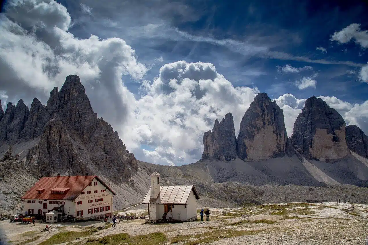
Some of the best backpacking hikes you can find are in the Dolomites, Italy.
- Location: The Dolomites, Northern Italy
- Distance: 9.1km
- Duration: 3.5 hours
- Difficulty: Easy
The hike to the spectacular Tre Cime di Lavaredo is one of the most popular day hikes in the Dolomites in Northern Italy.
The easy hike starts at the parking lot at Rifugio Auronzo in the East of South Tyrol and takes around 3.5 hours. Make sure to start your day early to beat the crowds, especially if you plan to take the hike during the peak season in mid-August.
If you feel more active, you can take the alternative trail 101 that adds an additional two hours to the hike.
I would absolutely recommend doing the detour on the way to the three peaks as it is less crowded and you will be able to enjoy even better views of the surrounding mountains during your hike.
Once you get to the Tre Cime di Lavaredo, you can recharge your batteries with a hearty lunch at the Rifugio Locatelli before heading back to your car.
Alternatively, you can also bring your own packed lunch and enjoy it sitting on the meadows around the three peaks. The view you will be able to enjoy during your lunch break is simply outstanding.
Contributed by Mike from 197travelstamps.com
Follow their adventures on Instagram
3. Hrebienok to Koprovsky Summit/ Lake Popradske, Slovakia
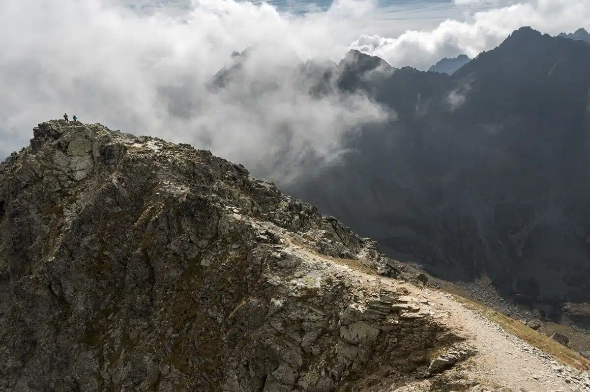
I had no idea Slovakia boasted such incredible scenery. This hike in the High Tatras looks and sounds amazing.
- Location: High Tatras, Slovakia
- Distance: Crica 25km
- Duration: 2 days
- Difficulty: Moderate
Part of the greater mountain line of Carpathians—High Tatras is the smallest mountain range in Europe featuring an alpine character.
With twenty five peaks soaring over 2500m, numerous tarns and a wide variety of flora and fauna, the Slovakian national park is considered a paradise for all sorts of hikers and climbers.
Among my favorite hikes in High Tatras is the one going from Hrebienok to Koprovsky summit (2363m) through the lake Popradske.
I love this route because it covers a great length of the mountain line while including a beautiful summit.
The trail starts at Hrebienok funicular station on a beautiful trail called Tatrnaska magistrala and goes west.
Walking initially through forest you will slowly ascend above the tree line and cross two tarns before descending to 1500m and the magnificent Popradske pleso, where you will spend the night.
The views on the way are magnificent and the moderate difficulty (16km, 960m elevation gain) makes it a great warm up for the rougher second day. Next day is the ascent to Koprovsky summit.
The trail starts at Popradske pleso and soon turns north along the bottom of Mengusovska valley where it steadily ascends to a plateau where the big and small Hincovo lakes are.
From there, you will climb to Koprovsky Pass via a steep zig zag path and carry on to the south ridge, which eventually leads to the top.
The whole distance to the summit is around 8.5km and the elevation gain almost 1000m but it’s totally worth it. The views from up there are really something to gaze upon.
The way back to Popradske and Strbske pleso (extra 50 minutes), where you can take the train, shouldn’t pose any difficulty.
The national park of High Tatras is open from mid-June to the end of October. I prefer to hike there past the first week of September to avoid the summer storms. These are usually hitting in the afternoon hours and can be extreme at times.
For this, it’s always better to start early in the morning and be back as early as possible.
Contributed by Chris from Trip and Trail
Follow their adventures on Instagram
4. Mulhacen from Mirador de Trevelez, Spain
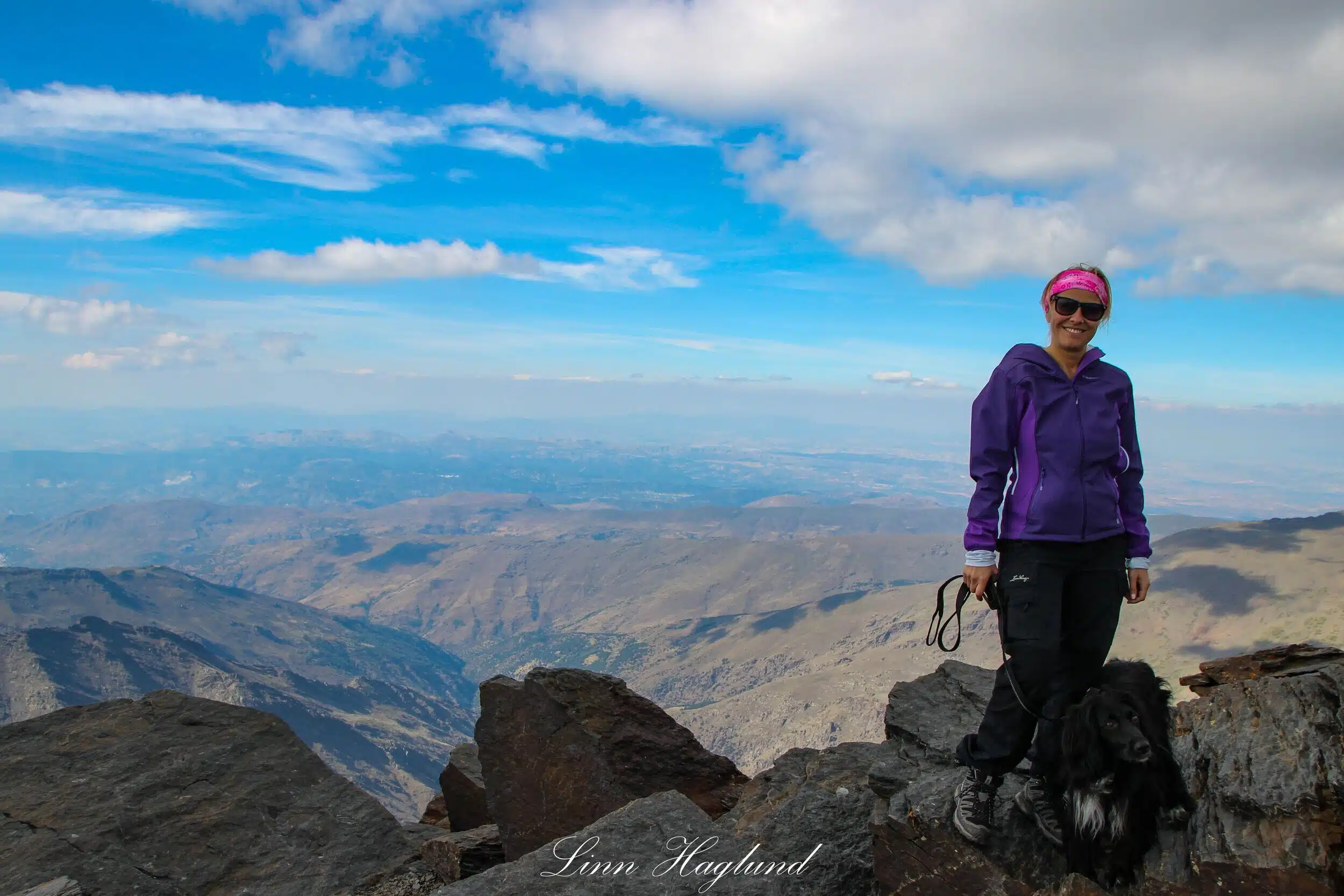
The best views in the country courtesy of the Mulhacen hike from Mirador de Trevelez in Andalusia, Spain.
- Location: Sierra Nevada, Andalusia, Spain
- Distance: 16km
- Duration: 6 hours return
- Difficulty: Easy to Moderate
Who doesn’t want to hike the highest mountain when you visit a country? And even more so when it’s accessible on a day trip!
Hiking to Mulhacen (3479 meters) can easily be done on a day trip from Malaga or Granada if you have a rental car. If not, I suggest you sleep in the village Capileira the night before you start your hike.
You need to get to Mirador de Trevelez in the morning. There are buses from Capileira, though they have to be booked in advance to secure a spot.
The bus comes back to pick you up exactly 6 hours after drop-off which leaves you plenty of time to hike to the top and down again.
This is not a hard hiking route, though the altitude can make you feel heavy-legged and give you a hard time breathing normally.
The views, however, make you forget the struggles as you can stop for a rest or a snack anywhere and enjoy the views of the surrounding mountains. If you are lucky, you might even see some mountain goats roaming around.
Make sure to not leave any waste behind, especially no food leftovers so the mountain goats don’t eat it and get used to human food.
Contributed by Linn from Brainy Backpackers
Follow their adventures on Facebook
5. Camino de Santiago, France/Spain
The Camino de Santiago is on my bucket list of must-do monster hikes. It sounds unreal and a genuinely life-changing experience.
- Location: French Pyrenees to Northwest Spain
- Distance: 800km
- Duration: 1 month
- Difficulty: Moderate to Hard
Hiking the Camino de Santiago in Spain is a quintessential trek for backpackers.
The pilgrimage route takes a little more than one month to complete. The hike begins in the mountains of the French Pyrenees and stretches 800 kilometers across the Iberian Peninsula to the town of Santiago de Compostela in northwest Spain.
The Camino is rooted in tradition – it began in the Middle Ages as a religious pilgrimage, but in recent years has gained a reputation as a bucket-list-worthy journey.
Hikers on the Camino carry only what they need in a backpack, then stay in albergues – the Camino’s version of a hostel – for the night.
Whether you’re hiking solo or with a companion, the comradery that results from hiking the Way is truly special.
Depending on the stage, the Camino de Santiago is considered moderate to challenging in difficulty, and the real test comes from the length of the journey itself.
Along the Way you’ll encounter a wide variety of terrains that all present different challenges. From the steep inclines and descents of the mountains to the unrelenting heat of the plains, there truly are no easy stretches of the Camino.
The Camino de Santiago is an epic hike for those looking to take on a big adventure and see a completely different side of Spain that you won’t find on the typical tourist trail…Plus when else do you have the opportunity to hike across an entire country?
For more Camino de Santiago tips, head to The Longest Weekend.
Contribute by Meredith from The Longest Weekend
Follow their adventures on Instagram
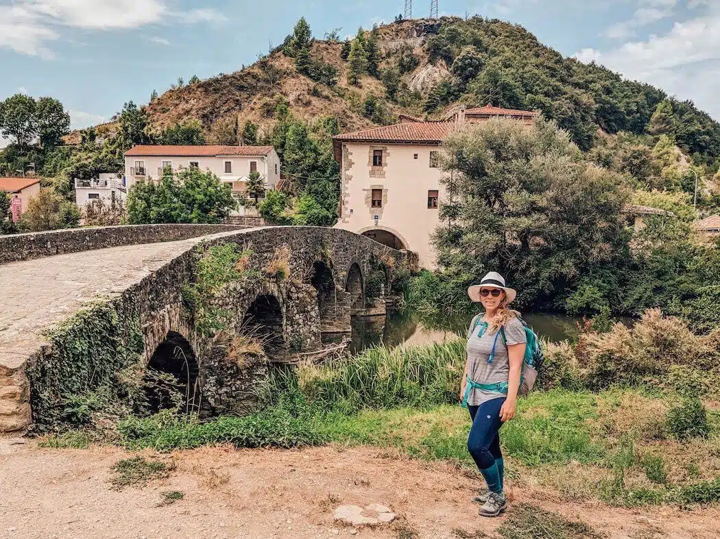
6. Fisterra-Muxia Way, Spain
Muxia looks pretty good too! Here’s another hike that’s worth checking out- especially if you’ve already doing the Camino!
- Location: Northwest Spain
- Distance: 30km
- Duration: 1 or 2 days
- Difficulty: Easy
Surely you have heard about the Camino de Santiago, named because among other things, it has as its end the cathedral of Santiago de Compostela in Galicia, Spain.
Since the middle ages, many pilgrims have approached on foot, on horseback and – more recently – by bicycle to this corner in the northwest of the Iberian Peninsula.
What I am not sure about is if you know that many of them continued their adventure walking to the coast. Thus, the road to Fisterra, the road to Muxía and the road between them: the Fisterra-Muxia.
And the latter is the one I want to recommend today because I did it with my partner last spring and had a blast.
With only two stages (or one, if you feel like walking the 30 km that separate both locations at once) it is perfect to discover this unknown corner of Spain, where mass tourism has not yet arrived.
It does not require much effort, although if you must be fit to walk 4 to 6 hours per day, go up and down slopes.
The rewards come in the form of views of the Atlantic Ocean, good Galician food and traditions at every step.
If you want more information, check out this little guide on the Fisterra-Muxía Camino. Enjoy!
Contribute by Inma from A World to Travel
Follow their adventures on Instagram
7. The Trolltunga Trek, Norway
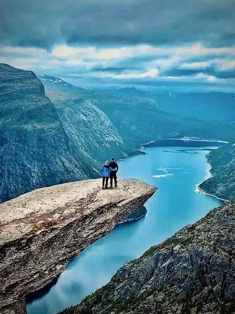
Norway’s another place that offers mind-blowing scenery. Just look at it!
- Location: Hardangerfjord region, Norway
- Distance: 20km
- Duration: 7 to 10 hours
- Difficulty: Moderate to Hard
Trolltunga is an unforgettable hike through Norway’s raw and remote Hardangerfjord region.
You will hike across wild landscapes with incredible views for 10km, gaining 800m in elevation until you arrive at the iconic Troll’s Tongue, an awe-inspiring tongue of rock literally hanging 700m above the turquoise sparkling fjord below.
This can be a tough (but not technical) hike, with much depending on the weather. Get a clear day with little wind and the stunning views will keep your mind off the huge boulder steps and sheer rock paths.
On a cooler and overcast day, the chances of rain are high and sudden drops in temperature are not unusual. Because this hike is remote you must ensure you are prepared and can go the distance.
Complete in a day over 7-10 hours or camp near the track and have an awesome sun-rise experience.
When you step on to the tongue and look down the fjord with its sheer grey cliff walls and sparkling water you will be speechless.
Take your life in your hands and sit on the edge for the ubiquitous Instagram shot and marvel at what Mother Nature has created in this most special and beautiful corner of Norway.
Contributed by Izzy and Phil from The Gap Decaders
Follow their adventures on Facebook
8. Cirque de Gavarnie, France
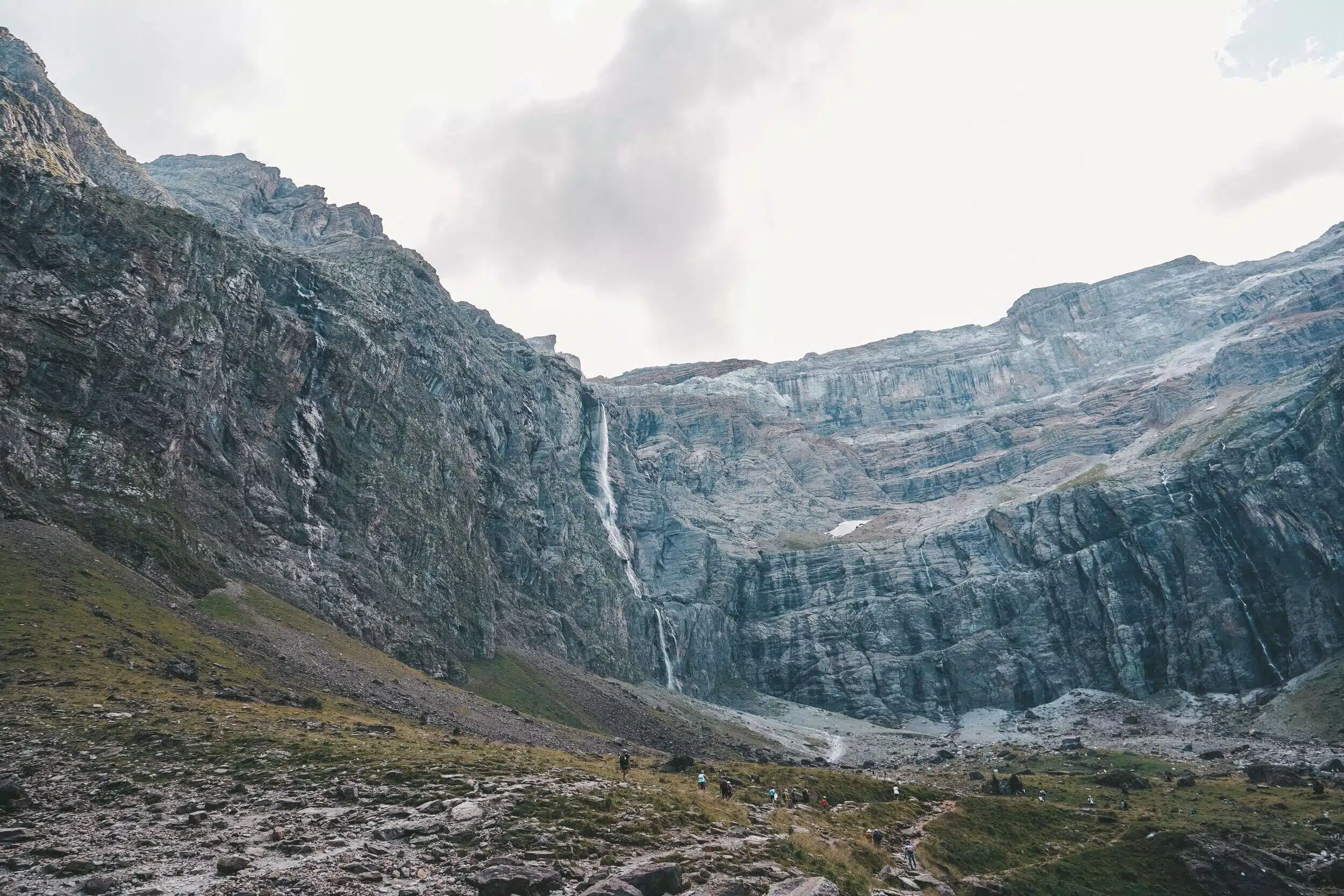
The giant waterfall that rewards your hiking efforts in Gavarnie, France!
- Location: French Pyrenees
- Distance: 13km
- Duration: 5 hours
- Difficulty: Easy to Moderate
One of the best hikes in Europe is the stunning 1-day circular hike in Gavarnie, France.
The hike is called Cirque de Gavarnie and it is located in French Pyrenees, on the border with Spain.
In fact, Spain is just a couple of km away, however, even though it is so close to Spain, the area definitely looks and feels like France and tourism is also mostly local.
Within 1 hike, there are multiple routes – the simplest one is just about 3 hours in total and the most difficult is probably about 9 hours or a bit less. The most common hike is around 13 km long and lasts for about 5 hours.
The difficulty is easy to moderate, there isn’t much of an ascent and you certainly don’t need to climb anywhere.
However, some parts of the trail are very narrow (especially if you pick the mountainside trail), so you need to have a decent physical condition. However, there are many trails that you can just pick the one you like most.
It’s best to hike Cirque de Gavarnie in summer, however, late Spring or early Autumn would work as well.
If you have a drone, you can bring it with you – the views in the Pyrenees are stunning. If you don’t have a drone, it’s absolutely fine, you would be able to capture stunning landscapes anyway.
The main highlight of the hike is the waterfall called Gavarnie Falls – the highest waterfall in mainland France. Its height is over 400 meters and it’s seen the strongest in early summer.
Contributed by Liza from Tripsget
Follow their adventures on Instagram
9. Sous Dine, France
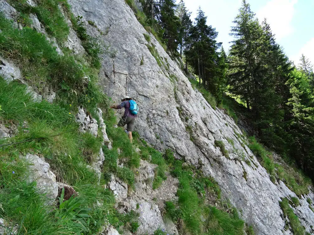
A technical section along Sous Dine. I can tell you from personal experience that this part of France boasts some insanely good hiking.
- Location: Between Geneva and Chamonix, French Alps
- Distance: 15km
- Duration: 6 hours
- Difficulty: Intermediate (with one difficult section)
Though the French Alps is absolutely crammed with stunning hiking trails, after living here for six months it’s Sous Dine that definitely takes the biscuit.
Sous Dine is conveniently located 30 minutes from Geneva and less than an hour from Chamonix.
If you’re driving there’s a car park right by the trailhead in Orange, or you can get a train to Saint-Pierre-en-Faucigny (it’s pretty simple to hitch to Orange or cycle as we did).
In this region there are many hikes and having explored most of them, the one I propose is the most exciting and rewarding!
The trail starts at the Orange carpark and begins zig-zagging through a beautifully mossy woodland with streams running by your side.
You’ll find hiking signposts the whole way; to begin with you’ll be hiking in the direction of Rocher Parnal and afterwards Sous Dine.
Once the woods are behind you, the only way is up.
The trail will lead you up towards Rocher Parnal, a tooth-like mountain that crudely juts up from the earth. The path joins the foot of the mountain and slowly skirts to its side.
This is where you’ll find the most technical part of the trail. There’s a 20m Via Ferrata section which, though physically easy, is pretty ballsy- don’t slip!
- Firstly, despite what you may think, it’s important to look down and make sure your feet are in the right place.
- Secondly, go slowly and if you’re concerned you can take a harness to fix to the lines.
With this section crossed, you can start to scale Rocher Parnal, over the valley top and gradually begin to summit Sous Dine at 2004m.
You’ll likely be joined by families of local Ibex and the views from the top will seriously blow you away!
It really is absolutely awesome hike, free from crowds, filled with natural beauty and finishing with breath-taking views across the French Alps, Switzerland and the Bornes Massif.
Contributed by Josh and Sarah from Veggie Vagabonds
Follow the adventures on Facebook
10. Skogar to Landmannalaugar, Iceland
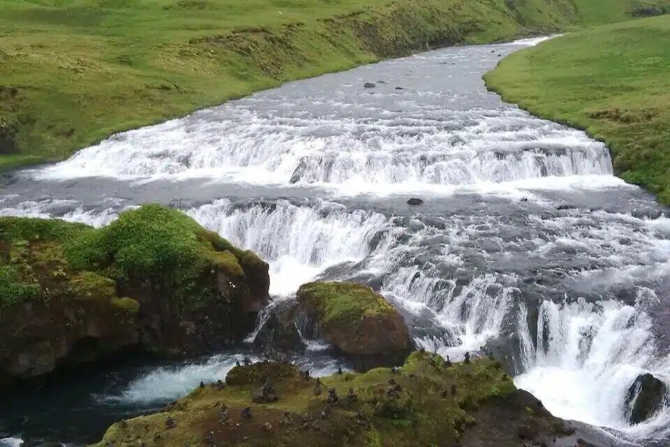
Iceland’s another place on my travel bucket list. The scenery looks unparalleled! This epic waterfall’s a prime example.
- Location: Iceland
- Distance: 88km
- Duration: 4 days
- Difficulty: Moderate
Iceland is more and more popular. However, some multiday hikes are not as popular among tourists, so it is still possible to have nature just for yourself.
One of these hikes is from popular waterfall Skogafoss to Landmannalaugar.
Landmannalaugar in the highlands is full of beautiful colourful mountains and some hot springs to refresh hikers after rough days’ on the trail.
But, before you get there, there are about 4 days of hiking, when you will have to walk through two glaciers.
It might sound dangerous, however, it is full of beautiful views.
On the way to the Landmannalaugur, there are couple of campsites. If you are sure that you want to hike this path, you should reserve them in a good time, since they don’t have too much capacity. But they will offer good food and drinks!
The hike is about 88 kilometres and it is located about 300 km from Reykjavík. It is mainly moderate in difficulty since you need to do this in summer; even then there is no assurance of good sunny weather.
Sometimes you will also need to go up steep hills.
So far it sounds like suffering, doesn’t it?
Well, the great thing about this is to have so much beautiful Icelandic nature just for yourself. Likewise, there aren’t many places where you can hike between two glaciers.
Even if it is a lot of sweat, it is definitely worth it.
Contributed by Albina from Ginger Around the Globe
Follow their adventures on Instagram
Bonus Best Europe Hike: Cinque Terre, Italy
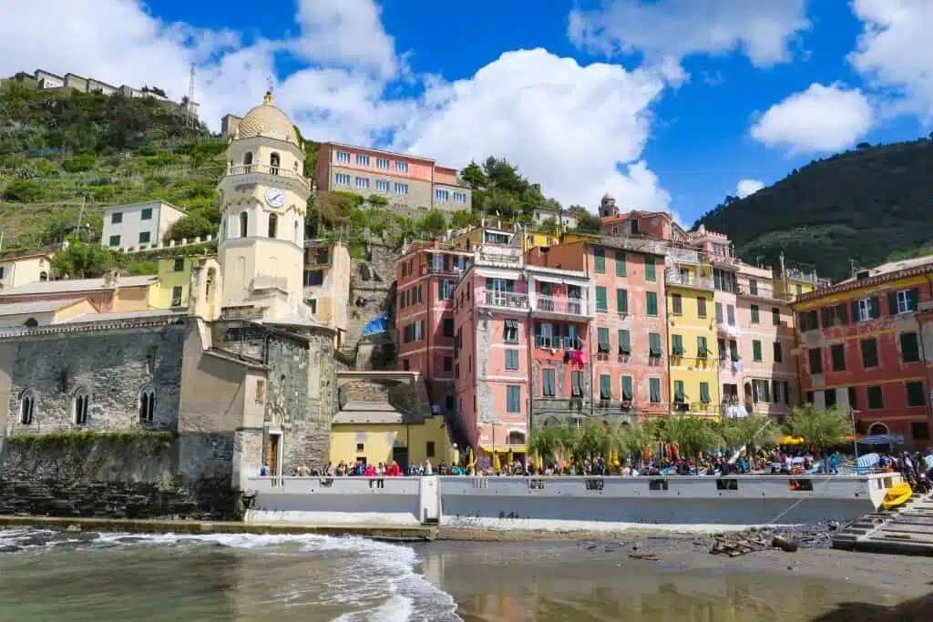
One of the stunning little towns along the well-trodden Cinque Terre- one of the best hikes in Europe!
- Location: Italy
- Distance: 88km
- Duration: 4 days
- Difficulty: Moderate
One of my favorite hikes in Europe, if not the whole world, is the mellow and easy hike between the five towns in Italy collectively referred to as Cinque Terre.
This isn’t a hike that is going to strain your abilities or make you feel a sense of accomplishment from overcoming obstacles; it is a hike done for one simple reason: amazing views.
Well, I suppose two other reasons are relevant as well, great Italian food and wine along the way.
Hiking Cinque Terre is moderately regulated. You will need to buy a permit to do the hike, which you can buy online for 7.5 euros (or 10 euros for the trail plus unlimited rail use). Going to the villages is free, but the card is needed for the trail between them.
You can hike the entire trail in only about five or six hours, as it is only about 15km long in total. But many people like to do it over a couple of days and stop for drinks and photographs in the various villages, since they are so beautiful.
The most popular way to enjoy the Cinque Terre on foot is to follow Trail #2 (the Sentiero Azzurro, or “Blue Trail”). That’s the route I recommend as well, for the best photographic opportunities.
Personally, I think it is better to do the trail from north to south, starting in Monterosso, because the slightly more difficult part of the trail is on that northern side.
Start with the slightly tougher part and by the time you are ready for some Lambrusco at the end of the day, you won’t need to worry about ordering an extra glass or two.
Contributed by Michael from Go, See, Write
Follow their adventures on Facebook
The Best Hikes in Asia
From Europe heading eastward, here’s a selection of the best hikes in Asia to enjoy. It’s a big continent and these are spread far and wide. All of these hikes sound as diverse and stunning as the continent itself.
Best Hikes in Nepal
11. Annapurna Base Camp Trek
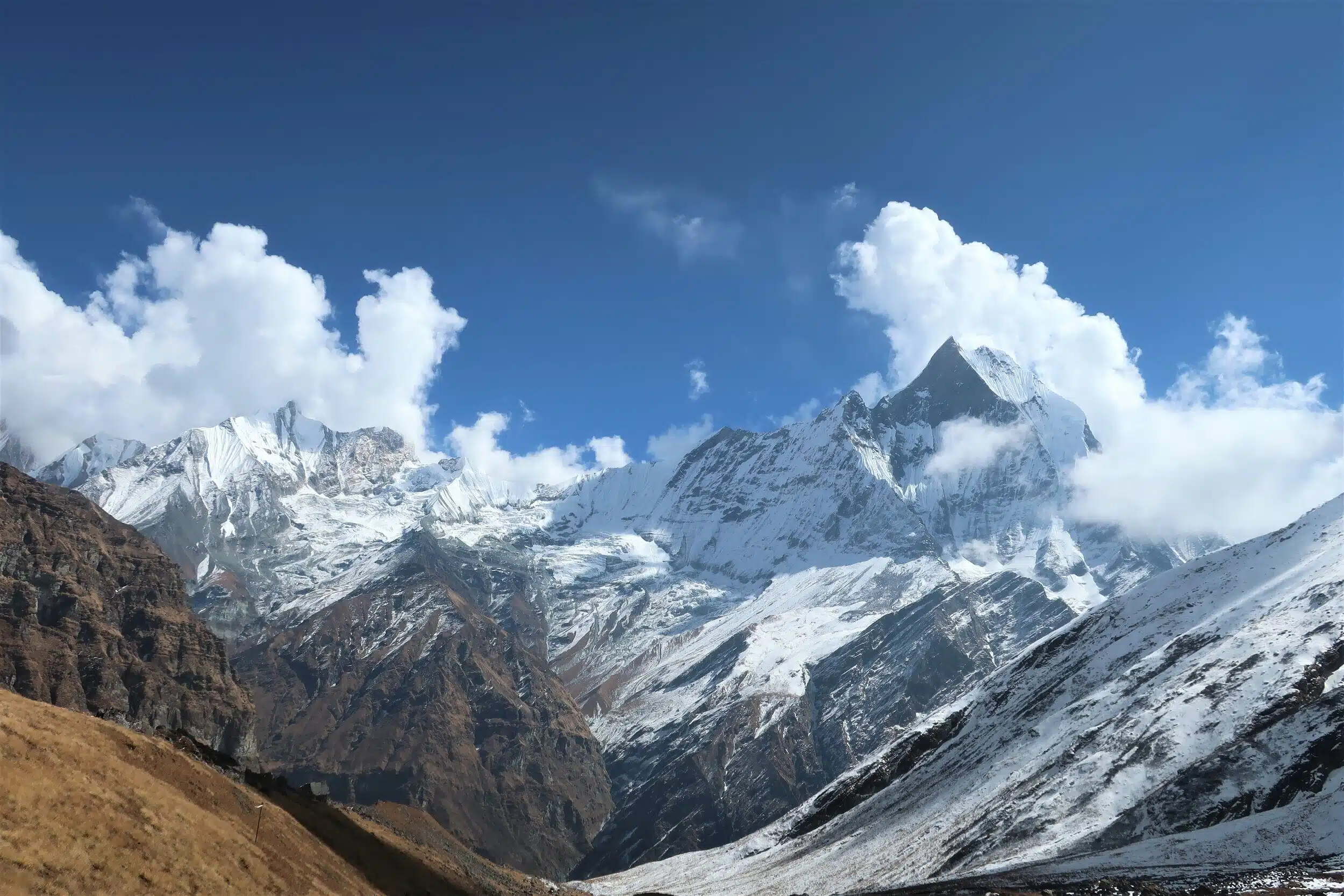
I can’t wait to go to Nepal one day. The Annapurna Trek is a world famous hike that sounds amazing- surely one of the best hikes in Asia, if not the whole world.
- Location: Himalayas, Nepal
- Distance: 115km
- Duration: 7 days
- Difficulty: Moderate (but long-distance and high altitude!)
The Annapurna Base Camp Trek is a great way to get a taste of trekking in the Himalayas.
The difficulty level is moderate and it’s also more affordable than the Everest Base Camp Trek.
But don’t assume that the lower price will give you a discounted view. Dare I say, I was more impressed with the view from Annapurna Base Camp than in Everest Base Camp.
But I’ll get into the details of that later. First let’s talk facts.
The trek to Annapurna Base Camp takes approximately 7 days.
We chose to combine it with the Ghorepani/Poonhill Trek, and it took 10 days to complete. The overall distance is approximately 115 km.
On average, you will be walking for 5-6 hours each day.
Be prepared for a lot of stairs. I’m not exaggerating. Every time I saw a set of stairs, I felt like Po from Kung Fu Panda.
But don’t be disheartened, the final view at base camp will knock your socks off.
The journey starts in Pokahara, a gorgeous lakeside city with a ton of trekking stores. If you would like a guide and/or porter, they can be easily booked in town.
But keep in mind the trail is well marked, it’s completely possible to complete the trek solo.
If you choose to go solo, make sure to obtain a TIMS card (Trekkers’ Information Management System) and an entry permit for the Annapurna Conservation Area.
Once you have these items, you can take a taxi to Nayapul, the starting point for the trek. If you want more details on our 10 day itinerary, check out the breakdown below.
But feel free to skip ahead to see why I enjoyed the view from Annapurna better than Everest Base Camp.
- Day 1 – Nayapul to Ulleri (1960 metres above sea level) – 4 to 5 hrs. hiking
- Day 2 – Ulleri to Ghorepani (2860 m) – 5 hrs.
- Day 3 – Ghorepani – Poonhill sunrise view (3210 m) – Chueli (2590 m) – 5-6 hrs.
- Day 4 – Chueli to Chomrong (2170 m) – 5 hrs.
- Day 5 – Chomrong to Dovan (2600 m) – 5 hrs.
- Day 6 – Dovan to Deurali ( 3200 m) – 4 hrs.
- Day 7 – Deurali to Annapurna Base Camp (4130 m) – 5 to 6 hrs.
- Day 8 – Annapurna Base Camp to Upper Sinawa – 7-8 hrs.
- Day 9 – Upper Sinawa to New Bridge – 5 hrs.
- Day 10 – New Bridge to Nayapul – 5 hrs.
The trek to Annapurna Base Camp takes you up to 4130 meters above sea level. Even at this altitude, you will still feel dwarfed by the 8000 meter mountains that surround you at camp.
The view is absolutely breath-taking.
The best part is there are teahouses right at base camp. You can stay the night and enjoy the view of the sunset and sunrise.
On a clear night, you can even see the Milky Way.
This trek is a truly humbling and awe-inspiring experience.
It leads you deep into the Himalayas, and you feel lucky to have a chance to stand amongst these giants.
Contributed by Millie from Amateurist Advice
Follow their adventures on Instagram
12. Langtang Valley Trek
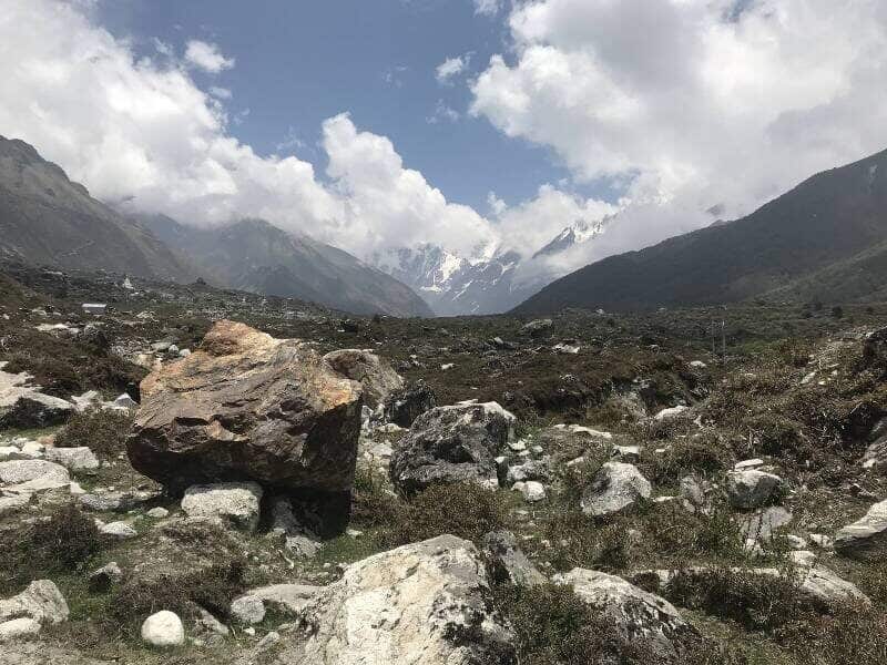
More otherworldly views in Nepal to look forward to.
- Location: Nepal
- Distance: 40km
- Duration: 1 Week
- Difficulty: Moderate
The Langtang Valley trek located in Nepal is something I’d highly recommend to anyone looking for an epic trek around the world.
Not only is the beautiful valley accessible from Kathmandu by road, but it also brings you in the surroundings of the beautiful Himalayas.
The hike up to the peak of Kyanjin Ri at a height of 4,773 m provides numerous opportunities to intermingle with the Tamang people of this region as you make your way along the old trade route to Tibet, allowing for an enjoyable cultural exchange.
A bonus of trekking in this region is the serenity it provides during the 40 kilometre journey and getting to experience it without the crowds.
You do need to purchase a Langtang National park permit to access the area and it can be done with or without the use of a guide and porters.
The hike can be described as moderately difficult, with accommodation in tea-houses along the way.
It takes just under one week to complete making it one of the best short treks in Nepal.
Contributed by Rai from A Rai of Light
Follow their adventures on Instagram
13. The Three Passes Trek
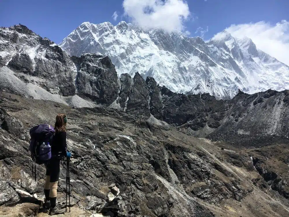
The Three Passes sounds pretty intense. What an unforgettable experience it must be to complete this particular hike in Nepal.
- Location: Nepal
- Distance: 166km
- Duration: 18 to 25 days
- Difficulty: Super Hard
If you are looking for one of the biggest and baddest hikes that backpackers can do, consider the Three Passes Trek in Nepal.
This trek takes about 18-25 days to cover 166 km, depending on how many rest days you take.
The three highlights are going over three high mountain passes, all 5300m+ in elevation and with incredible views: Kongma La, Cho La, and Renjo La.
The famous Everest Base Camp trek and Kala Patthar summit at 5550m, and Gokyo Ri with its glittering turquoise lakes are all side-treks from the Three Passes Trek.
As a backpacker, I took a DIY approach to trekking the Three Passes Trek, and it cost me $700 USD total.
I didn’t hire a guide or porter, and I took a jeep from Kathmandu to Salleri and hiked three extra days to Lukla (instead of flying directly into Lukla).
While many people will warn you against taking on this trek without a local guide or porter, budget backpackers should know that it’s possible to hike this without spending thousands of dollars.
This trek should not be underestimated, and only those with at least a medium level of physical fitness and some high-altitude experience should attempt the Three Passes Trek.
Pass days require you to ascend hundreds of meters up to the mountain pass, then descend steep terrain back down to the next village.
It can take up to 12 hours to get from teahouse to teahouse.
Two of the three passes also require you to cross over glaciers of crumbling ice, so crampons are highly recommended.
Contributed by Erika from Erika’s Travelventures
Follow their adventures on Facebook
14. Adam’s Peak (Sri Pada), Sri Lanka
I climbed Adam’s Peak on a rainy day back in 2013. The steps were memorable, but I had no view at all! I’d happily climb back up those stairs for a sunrise view like this!
- Location: Sri Lanka
- Distance: 5000 to 6000 steps
- Duration: 3 to 4 hours
- Difficulty: Easy to Moderate
Hiking Adam’s Peak in Sri Lanka is both a memorable physical and spiritual experience.
Located in the Southern region of Sri Lanka, Adam’s Peak is one of the most important Buddhist pilgrimage destinations in the country (it’s also a must for your Sri Lanka itinerary).
From December to May, tens of thousands of Sri Lankans and a few thousand foreigners hike the sacred mountain.
They’re there to take a look at a small depression on the ground of the summit, believed to be a footprint of Buddha (although some Christians and Muslims believe this is actually the first footprint of Adam’s on Hearth, hence the name Adam’s Peak).
The hike to the top of Adam’s Peak is usually done at night in order to reach the summit by dawn.
The sunrise from there is absolutely gorgeous, and you will get a chance to see the enigmatic shadow of Adam’s Peak on the surrounding valley:
A surprisingly perfect triangular shadow, that doesn’t seem to match the actual irregular shape of the mountain!
Most visitors depart from Dalhousie, around 2 am.
The first hour or so is an easy slightly uphill walk passing some shrines and a Peace Pagoda built by the Japanese in 1970. Then the real climb starts, with steps getting shorter and higher.
The last 1000 steps are really steep but there are very helpful handrails.
During the pilgrimage season, it is easy to take breaks in the many shacks lining up the trail, selling tea, coffee, and snacks.
It gets bitterly cold at the summit so aim at reaching the summit not too early before sunrise and make sure to pack some warm layers of clothes too.
With a reasonable fitness level, the hike should take around 3 to 4 hours.
Avoid at all cost public holidays and full moon nights, as the crowd of a local pilgrim can slow down the hike, or even make it impossible to reach the top.
The walk back down takes around 2 hours and most visitors are back in Dalhousie between 8 and 9 am.
Aside from the physical experience, it is also a very strong spiritual one.
Most of the hikers are local Sri Lankan, of all ages and physical conditions.
Climbing along very old men in flip-flops, or young mothers with their babies, really makes you reflect on the power of faith.
Contributed by Emma from Bonjour Sunset
Follow their adventures on Instagram
15. Kalaw to Inle Lake, Myanmar
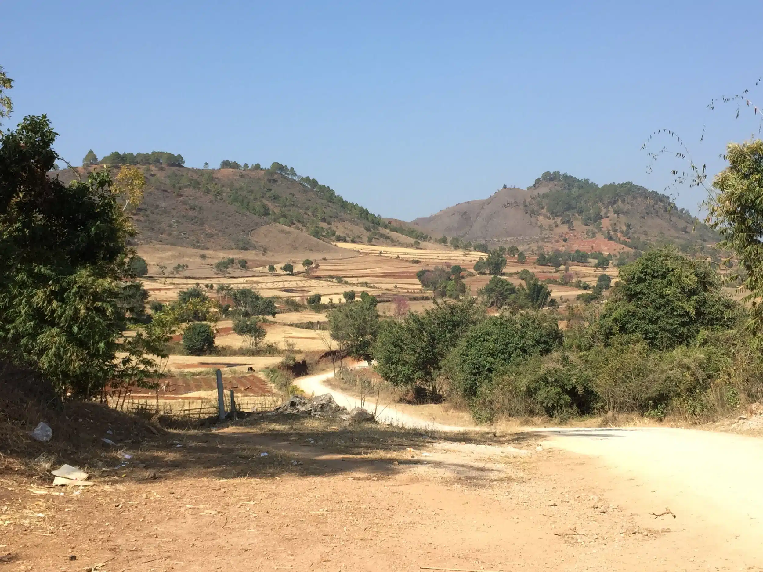
The best hikes in South East Asia that I’ve done have all been in Cambodia and Thailand. This one in Myanmar sounds just as good though!
- Location: Myanmar
- Distance: 35+ km
- Duration: 2/3 days
- Difficulty: Easy
A hike in Myanmar’s countryside is a great way to round out your trip to Burma as there’s more to see than just its well-known temples in Bagan.
A1 Trekking in Kalaw offers a 1 or 2-day trek around Kalaw, or a 2 or 3-day trek from Kalaw to Inle Lake. I did the 2-day, 1-night trek from Kalaw to Inle Lake.
I chose this hike as I wanted to spend some time in nature and at the Lake as it always looked so peaceful and beautiful in pictures. Doing this walk not only allows you to see more of Myanmar’s backcountry but also different villages/vegetable plantations along the way.
This trek is suitable for any level, but a lot of walking happens in 2 days.
On the first day, you will walk 20+ km, around 6 hours, and on the second day, you will walk 15+ km, approx. 4 hours. The hike costs $70 for 1 person, $50 for 2-5 people and $40 for 6 or more people. You will most likely be paired with other people, so don’t worry about paying the highest price.
Accommodation, luggage transport, food, and a guide are included. However, the transport from the boat jetty to the other side of Inle Lake isn’t covered in the cost. The boat is 17000 kyats/5 people.
Do note that the accommodation is also very basic. In other words, you will be sleeping on a mat on the floor, but with big and warm blankets, so you won’t be cold!
One thing that I didn’t like about this hike is that while you do see and stay in local villages, you will still be surrounded by many other tourists doing similar walks to you. And you’ll probably see most of them in the village you spend the night at!
Nonetheless, it was an interesting experience, and the guides were friendly, reliable, knowledgeable and spoke good English.
I also never once felt unsafe with them or the family I stayed with, who was also very welcoming and accommodating. The food was fantastic as well, and vegetarian options were available, which was highly appreciated being one myself!
Contributed by Loredana from Destguides
Follow their adventures on Twitter
16. Magome to Tsumago, Japan
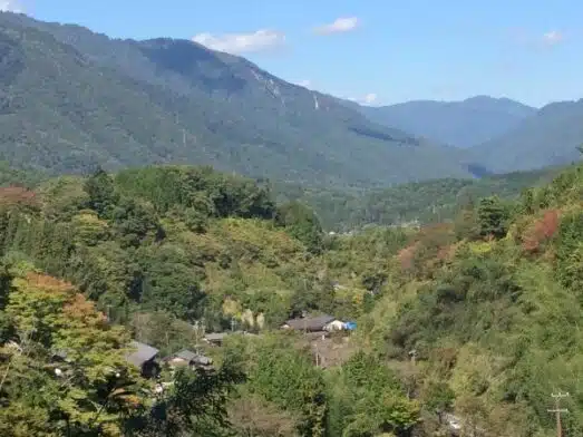
It’s a small picture, but it gives an undeniable sense of the immense beauty of the Nakasendo trail!
- Location: The Nakasendo Trail, Japan
- Distance: 8km
- Duration: 3 hours
- Difficulty: Easy
The Magome to Tsumago day hike is an excellent day hike that follows part of the historic Japanese Nakasendo Trail.
This is the old Edo period trail between Kyoto and Tokyo, it winds its way between historic post towns.
The Magome to Tsumago part of this route is perhaps the best known day hike in Japan and is just a short 5 miles (8 kilometres) of gentle trails.
The path is well-formed and partly follows the road, partly undulates through woodland, but lets you see a gorgeous part of the Japanese Alps.
The route is well signposted and staff in the tourist offices in Magome and Tsumago are well informed of the needs of travellers.
There’s a luggage transfer service between the two towns and some gorgeous ryokans to spend the night in should you wish to really experience this old postal town trail.
There are gentle elevation gains at either end of the trail and a super little traditional tea house in which to take refreshment en route.
The trail itself will take no more than 3 hours and is an easy walk.
There are excellent public transport links to Magome – the closest JR station is Nakatsugawa, from where a bus connects Magome and the train station in Tsumago can also easily be reached.
Contributed by Sarah from A Social Nomad
Follow their adventures on Facebook
17. Cross over Mestia to Koruldi Lakes
Anyone fancy a hike in the snow? Mestia in Georgia has you covered!
- Location: Mestia, Svaneti Region, Georgia
- Distance: Circa 10+ km
- Duration: Whole Day
- Difficulty: Easy to Moderate
In the north-west of Georgia, where the mountains serve as a natural border with Russia, there’s the Svaneti region.
Its capital, Mestia, is known as the adventure center in the Caucasus country. In winter you’ll find a world-class ski resort, and the rest of the year you’ll get as many hikes as the time you leave in your itinerary.
I visited during early spring, when there was still snow on top of the peaks that surround the city.
My favorite hike was to the cross over Mestia, which takes you up to a steep hill overlooking the town, where you get a 360° view of the whole valley, and to the higher summits hidden behind this hill.
It’s 800 meters of ascent to get to the top of Tshakazagari mountain, and there are two different routes:
One around the hill in a zigzag jeep track – longer but easier; and a much steeper one, but in a normal hiking path, surrounded by nature.
Even if you’re not that fit, take the latter.
You can make a ton of photo stops (and you will want to even if you don’t need to catch your breath), and you’ll be treated to a gorgeous textbook hike:
Walk up from the city, pass through its landmarks (the Svaneti towers), trek in the middle of a forest, go across a stream of water, with stunning ever-changing views.
Next to the cross there’s a wooden shelter you can climb, where you can relax and enjoy the panorama.
Up to here it’s about 3.5 km, which should take around two and a half hours.
As the path from then on was covered in snow, I couldn’t reach the Koruldi lakes (which were also covered in snow).
But if you’re aiming to get to them, just follow the signs. Actually, the whole trail is well marked.
Just continue going up through the ridge of the mountain.
From here on is much less steep (although it goes steadily up), but the hardest part is done! It should only take you an extra hour and half.
Count on the whole day for this hike, or start super early if you have other plans for the afternoon.
Contributed by Coni from Experiencing the Globe
Follow their adventures on Instagram
Best Hikes in India
18. Hampta Pass Trek
Look how beautiful India is! The Hampta Pass is another of the best hikes in Asia that looks amazing.
- Location: Himachal Pradesh, India
- Distance: Circa 26km
- Duration: 5 days
- Difficulty: Easy to Moderate
Hampta Pass trek also known as beginners’ trek as it is the easiest among all the treks of Himachal Pradesh, India.
The magnificent trek is in the beautiful southern part of Manali (H.P) and got its name from Hampta village.
This trek is used by shepherds and villagers to reach Lahaul Spiti valley of Himachal Pradesh. The whole trek takes five days to complete from ‘Manali to Chandrataal Lake’.
The highest altitude is an impressive 14,100ft.
It has also got spiritual importance and is famous among Hindu pilgrims as the ‘Stairway to Heaven’. According to Hindu Epic ‘Mahabharta’, Pandavas traversed through this path while on their way to heaven.
It was Chandrataal where ‘Yudhishtra’ the eldest brother of Pandavas, was taken to heaven in his mortal form.
The beautiful trail includes lush green meadows, rivers, glaciers, stunning landscapes, and deodar forests make the hike even greater.
The best time to visit this trek is May-June and September-October.
Contribute by Supriya from Traxplorers
Follow their adventures on Instagram
19. The Roopkund Trek, India
This stunning photo shows the beauty on offer in Northern India. Imagine hiking through those mountains!
- Location: Uttarakhand, Northern India
- Distance: 55km
- Duration: 5 to 6 days
- Difficulty: Moderate to Hard
Roopkund trek of Uttarakhand is home to the mystical Skeletal Lake with the stunning views of Trishul Peak.
The frozen Roopkund Lake is an offering to the Nanda Devi, making this adventure also a spiritual one. The starting point of this trek is at Kathagodam in Nainital of Uttarakhand.
The nearest airport would be the Delhi airport and from here you can find a train and buses to Kathagodam.
The best time for this trek is July to November when the weather is cool.
The trek is stretched over 55 km to be covered in 5 to 6 days and the altitude is 16,500 ft. The rich history and culture of the locals are fascinating with very old temples and traditions.
Permits are required for forest entry along with valid ID proof.
After reaching Kathagodam you travel to Lohagunj through the bumpy roads. It is a small village with basic amenities.
From there the trek starts to the largest meadow in Asia Bedni Bugyal.
The dense oak and rhododendron forests are treat to one’s eye and you get to enjoy nature at its purest form, untouched by modernization, people taking their cattle for grazing, children walking to schools.
It is an amazing experience, you should definitely go for this trek.
Contribute by Shalini from Eager 2 Travel
Follow their adventures on Facebook
Love to hike? These buying guides should help you find the gear you need.
The Best Hike in Africa
There’s bound to be thousands of incredible hikes in Africa. However, here’s just one to whet your appetite for more!
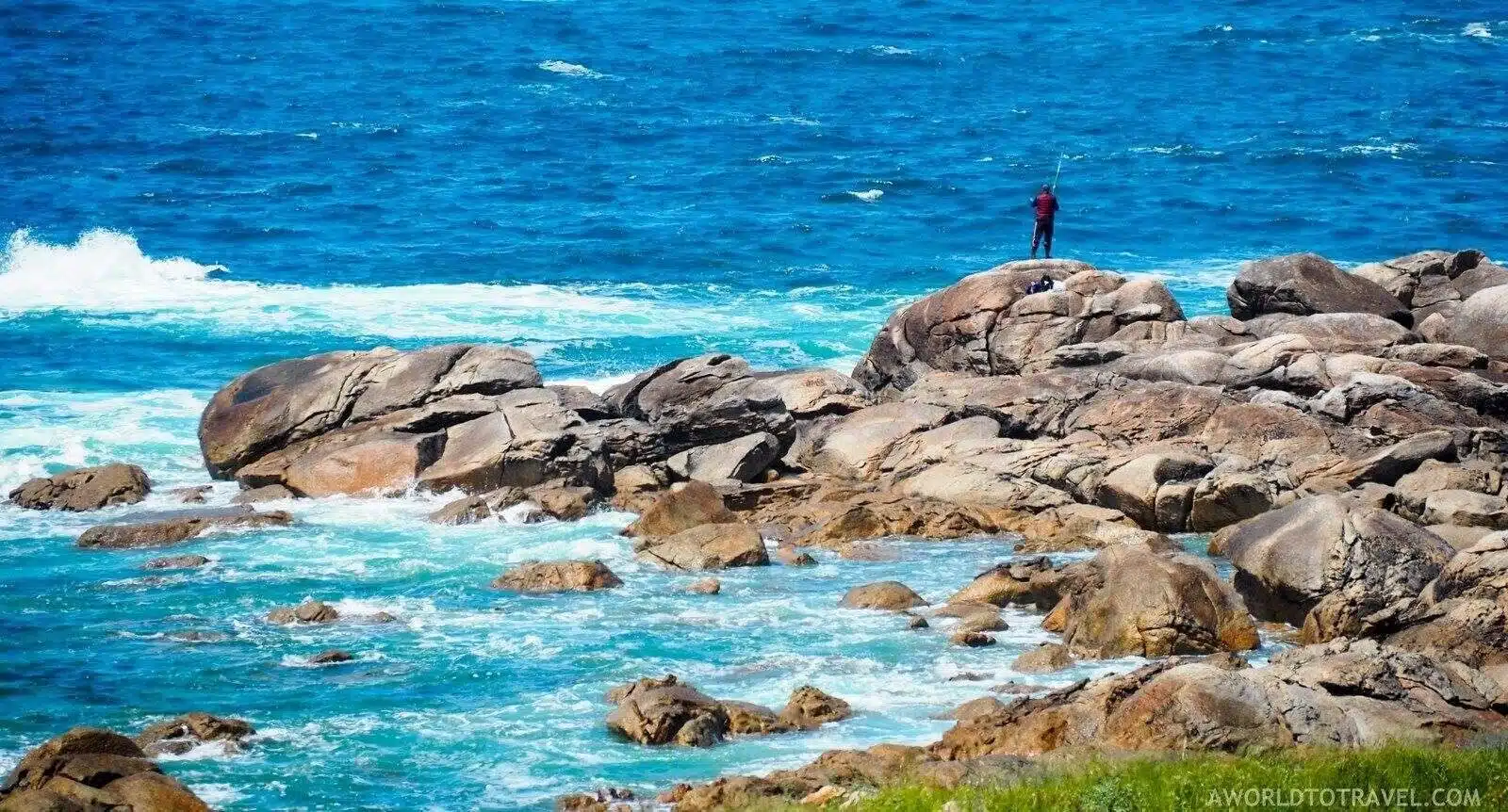
20. Cha de Igreja to Ponta do Sol, Cape Verde
I knew literally nothing about Cape Verde before putting this post together. This pic (and the hike) has definitely put it on my map!
- Location: Santo Antao, Cape Verde
- Distance: 14km
- Duration: 6-7 hours
- Difficulty: Moderate
Despite being an uncommon destination for backpackers and tourists in general, the western islands of Cape Verde have some great things to do.
If you love hiking, you should definitely head to Santo Antao, the most western of the archipelago. It is characterised by a very dry southern part, divided from the lush and green northern area by a mountain chain.
While this area is the most famous for trekking in Santo Antao, I’d recommend you explore other areas, including the coast.
My favourite hike of the island is all along the sea.
Blue waters and steep cliffs are the predominant natural elements. I suggest you do resist the instinct to swim there, as the stream is very strong in this part of the Atlantic Ocean.
The hike starts in Cha de Igreja, a small village, and ends in the bigger Ponta do Sol after forteen kilometres and a six to seven hours walk.
It is not one of the most difficult hikes of Santo Antao, but it is of medium level.
The heat and lack of shade can be very tough. There are also a couple of steep climbs that will test your fitness.
The highlights of the hike are a couple of very nice villages that you will encounter on your way to Ponta do Sol: in particular the famous village of Fontainhas, with its colourful houses on top of a cliff.
Contributed by Mario Migliore from Rest and Recuperation
Follow their adventures on Facebook
The Best Hikes in Oceania
Moving onto some of the best hikes in Oceania. Here are a few top hikes to enjoy in Australia and New Zealand.
Best Hikes in Australia
21. The Great Ocean Road Walk
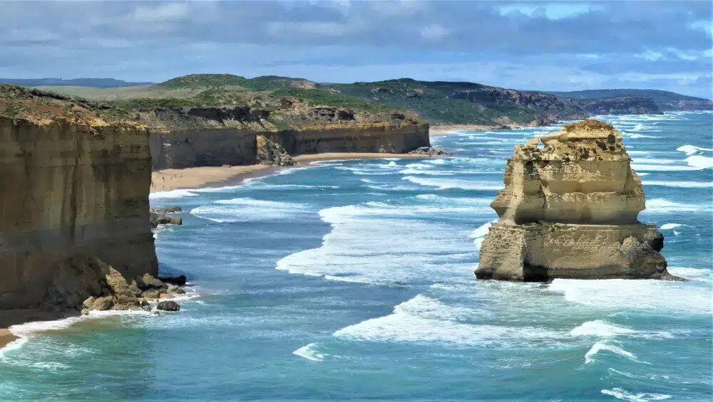
I literally drive the Great Ocean Road last week! The views are unforgettable every step of the way. I can imagine walking this trail would be equally impressive.
- Location: Victoria, Australia
- Distance: 104km
- Duration: Multiple days/Divide into sections
- Difficulty: Easy to Hard
The Great Ocean Road walk is one of the most beautiful walks in the world, running for 104 kilometres from Apollo Bay to The Twelve Apostles across Southern Victoria in Australia.
It winds its way through the Great Otway National Park, rugged coastline typified by The Shipwreck Coast and pristine wilderness areas accessible only from the walking trail.
The unique aspect of this walk is it has something for everyone.
Depending on time available and fitness levels, a visitor can do the entire walk over a number of days, or choose to do one or more sections. There are numerous trailheads along the way making access to the sections easy and straightforward.
There are eleven sections to the walk. In terms of difficulty; five are classified as Easy/Medium, four as Medium, two as Medium/Hard.
The longest section is Devil’s Kitchen to The Twelve Apostles at 16 kilometres, walking time of 5 hours with an Easy to Medium level of difficulty.
The rest are shorter and take less time.
The most challenging section is Melanesia to Ryan’s Den, a distance of 9.5 kilometres and 3.5 hours. The easiest section is Apollo Bay to Marengo, a distance of 3 kilometres and 1 hour.
Time required to comfortably walk the entire length is around 36 hours over 6 to 8 days; depending on fitness levels.
The walk can be done as a self-guided experience allowing total immersion in the beauty of the region; staying at small, purpose-built campgrounds along the way.
Alternatively, at the end of each day tour operators can take visitors to overnight accommodation where they can indulge themselves in the best the area has on offer.
The weather is a factor here. The best time to walk is during the Summer months (Dec – Feb) with lower rainfall, warm days and mild nights.
Contributed by Keith from Travellin’ Lite
Follow their adventures on Pinterest
Best Hikes in New Zealand
22. Lake Marian
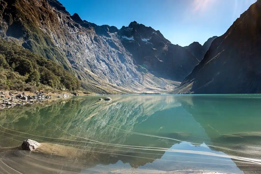
If you ever want a picture that sums up the incomparable beauty of New Zealand, this is it. The Fiordlands are something special.
- Location: Fiordland, New Zealand
- Distance: 4.8km
- Duration: 3 hours
- Difficulty: Moderate to Hard
When you think of New Zealand, you possibly think of the beautiful photos at Mitre Peak in Milford Sound.
Touted as perhaps the 8th Wonder of the World, it certainly is a beauty hidden in a beautiful wilderness.
But what people miss, when hightailing it for one of New Zealand’s must do attractions, is the incredible beauty hidden along the way.
So if you don’t want to just knock another attraction off the list, and want to find something showstopping that many have never heard of, then head to Lake Marian in Fiordland.
Just 5 minutes off the Milford Road, and 40 minutes from Milford Sound itself you will find this awesome hike. While it is only a half day hike, 3-4 hours return, the terrain is rough and it is not a walk in the park.
Running shoes are a minimum but hiking boots are better.
You can imagine what the terrain would be like, if you were walking up a dry river bed, with all those stones, coupled with tree roots from yesteryear, then that is what the track is like the whole way to the top.
The first 15 minutes is a relatively flat, carefully crafted path and this will take you to Marian Falls, but after this, it is a steep uphill climb to the top.
This will take most people around 90 minutes, up to 2 hours with breaks along the way.
Lake Marian is your halfway point, an alpine lake nestled in the middle of nowhere. But it is beautiful, sitting in the shadow of the mountains.
Be aware there’s not a lot of flat ground for sitting, and if you are up for a swim, it will be mighty cold.
Contributed by Jennifer from Backyard Travel Family.
Follow their adventures on Instagram
23. Roy’s Peak
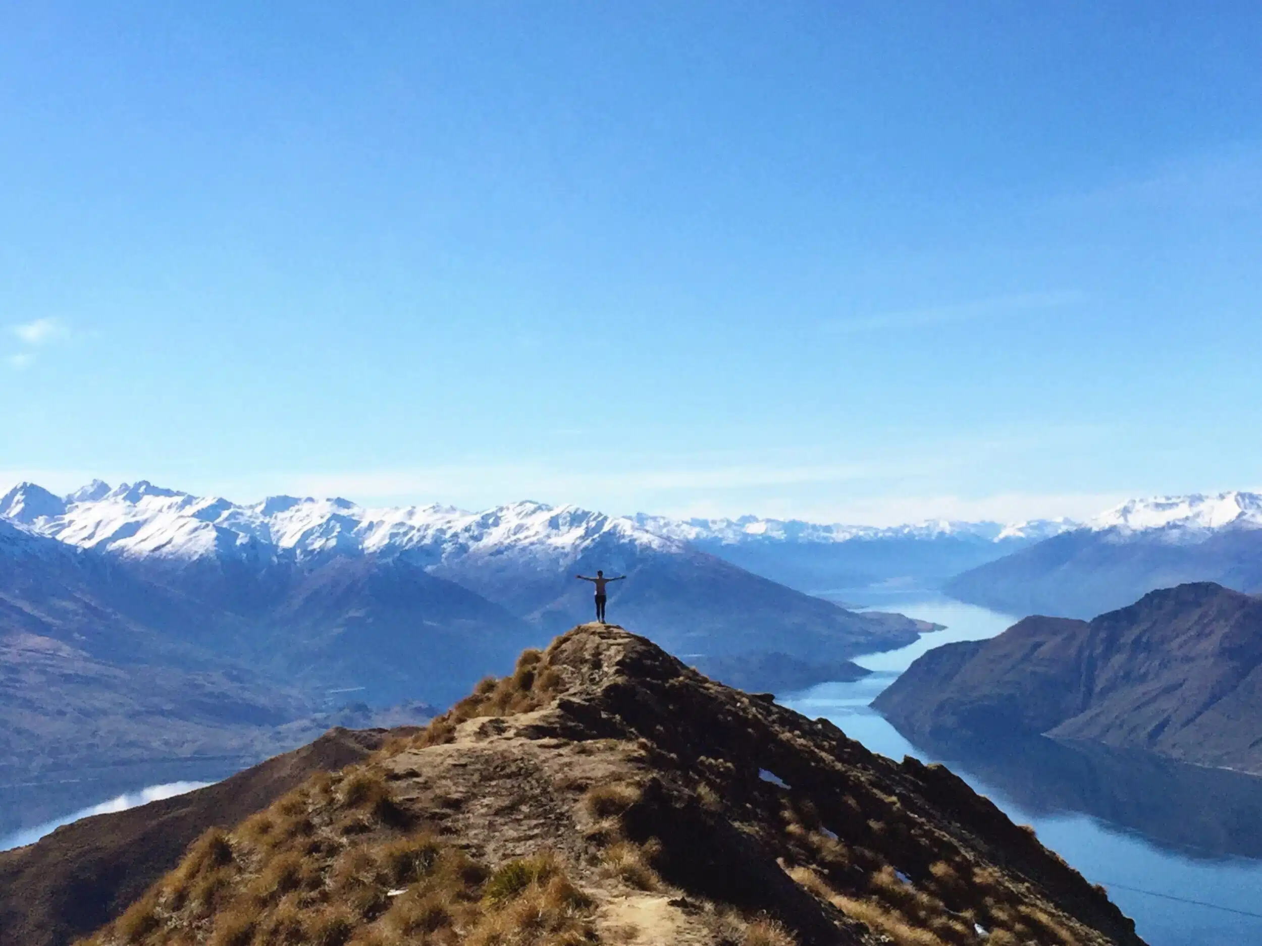
Having climbed Roy’s Peak a couple of times myself, I can vouch for this hike! Those views make the leg burning ascent worthwhile
- Location: Wanaka, New Zealand
- Distance: 16km return
- Duration: 5 to 6 hours
- Difficulty: Moderate
One of my absolute favorite hikes that I did while I was in New Zealand was Roy’s Peak in Wanaka, New Zealand.
Located in the beautiful Otago region of the South Island, the hike at Roy’s Peak provides breathtaking views from every angle.
The trail is 16km return using the same track and will take about 5-6 hours to complete. It is a very steep hike that never really lets up, so a good amount of fitness level is recommended.
It’s also a popular day hike in the area so expect a lot of other hikers to be present, especially on a nice day.
The track begins at the Roy’s Peak Track car park on Mount Aspiring Road not too far out of town.
The beginning of the climb will take you through low grassland and it doesn’t take long to start catching a bird’s eye view of Lake Wanaka and the surrounding peaks of the Southern Alps.
With no trees around to block your view, the picturesque Wanaka region only gets more beautiful as you continue to climb.
The glistening lake and snow-capped mountains in the distance make this a one of a kind hike.
It can get windy and the temperatures drop as you get closer to the summit so be sure to bring a jacket, hat and plenty of sunscreen & water.
About 30 minutes from the top is a false summit where you will likely see many people taking turns to get a picture.
From here you can decide to keep going to the very top or turn around and head back to the parking lot.
Regardless of what you choose, as long as there is good weather, this hike will not disappoint you.
Contributed by Tayler from Traveling Tayler
Follow their adventures on Facebook
Want to learn more about New Zealand? Be sure to check all of my NZ content here.
The Best Hikes in South America
Here’s a selection of the best backpacking hikes in South America to sample. Each and every one of them sound incredible.
Best Hikes in Peru
24. Laguna 69
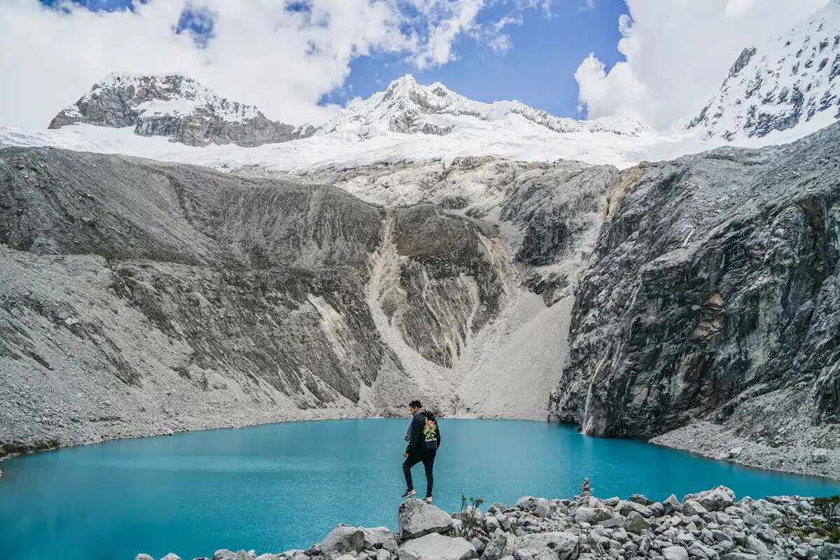
That water looks out of this world. Laguna 69 seems like another epic hike with stunning scenery to reward your efforts.
- Location: Peru
- Distance: 12km
- Duration: 5-hour return
- Difficulty: Hard
Laguna 69 is one of the many stunning glacial lakes located in the Cordillera Blanca mountain range in Peru.
It is a perfect, but exhausting day trip for glacier and mountain lovers or anyone that is up for some difficult hiking.
The hike itself takes about 3 hours up and two hours down. The path itself is only 6 km one way but you are gaining 800m in altitude in that 3 hours.
Needless to say, the path up is extremely exhausting and breath-taking in every sense!
But what is more breath-taking is the views that you have on your entire journey. Snow-capped mountains, wildlife, tundra-like vegetation, everything on the Laguna 69 is unforgettable.
After 3 hours of strenuous hiking, you will finally arrive at Laguna 69.
Laguna 69 is located 4500m above sea level. It is an altitude that will give some of the most experienced hiker’s altitude sickness.
But when you stand in front of the Laguna 69 and its beauty, the pain and the headache (trust me, you will get headaches) will go away.
Now I understand why people quit their high-paying jobs in the concrete jungle and take their backpacks to travel the world.
To hike to Laguna 69, you will want to base yourself out of the city of Huaraz, a city 3000m above sea level surrounded by snow-capped mountains.
While you are there, check out the other hikes and treks you can do in Huaraz.
Contributed by Sean from Living Out Lau
Follow their adventures on Instagram
25. Colca Canyon Trek
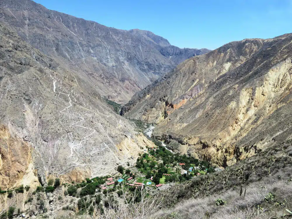
I’ve literally never been anywhere like Colca Canyon in my life! Walking to an oasis in the middle of such an arid landscape must be incredible.
- Location: Colca Canyon, Peru
- Distance: 20km
- Duration: 2 to 3 days
- Difficulty: Hard
The Colca canyon is one of the most beautiful areas in Peru and a popular tourist attraction near Arequipa.
Most people visit the canyon by bus on a day trip, but this way you miss out on a lot this area has to offer. The best way to explore the Colca Canyon is by hiking the Colca Canyon trek.
The Colca Canyon trek is not as famous as the Inca trail, but has equally stunning sceneries. Although it is challenging it is worth the effort.
The Colca Canyon is twice as deep as the Grand Canyon!
Therefore, it is a long descent into the canyon and then a steep climb out again.
While possible in 2 days you will do yourself a pleasure to do this difficult hike in 3 days. This will allow you more time to see some of the villages in the canyon where women often still wear their colourful traditional clothes.
Staying overnight in one of these places is a memorable experience.
There are a lot of small scale guest homes that feel more like a homestay.
Most people spend their last night in the oasis- a rather touristy place at the foot of the long steep climb out of the valley.
It will be difficult, but once you reach the top and see the magnificent views you know it was worth it. If you are lucky you might even see the Andean Condor that flies through the valley.
It is one of the largest birds in the world.
Contributed by Ellis from Backpack Adventures
Follow their adventures on Instagram
Best Hikes in Colombia
26. El Cerro de las Tres Cruces
Hiking to those crosses sounds like hard work! The views from the top are meant to be totally worth it though.
- Location: Cali, Colombia
- Distance: 1.6km
- Duration: 1 hour
- Difficulty: Moderate
Famous for its mountains and biodiverse landscapes, Colombia is a great place to be as a backpacker.
So, if you find yourself in the land of coffee and looking for a great hike, be sure to check out El Cerro de las Tres Cruces in Cali.
This is an infamously steep hike that is great for beginners and can easily be done in half of a day.
As a backpacker keeping fit and healthy whilst traveling should be a priority.
With the intense heat in a place like Cali, it is best to start this type of hike first thing in the morning, before the sun starts to get blazing hot during those midday hours.
One of the greatest things about this hike is the viewpoint that you encounter on the way up the mountain. The local Colombian people love this hike because it gives you some of the best views of Cali.
Not to mention, the 3 giant crosses that sit on the mountain top which have cultural significance.
If traveling to Cali from another city in Colombia you can take a bus and on arrival head to the San Antonio neighbourhood.
There are two access points located close-by which you can use to be able to start the hike, both of which can be found on most tourist maps.
Contributed by Daniel James from Layer Culture
Follow their adventures on Instagram
27. The Cocora Valley Hike (Valle de Cocora)
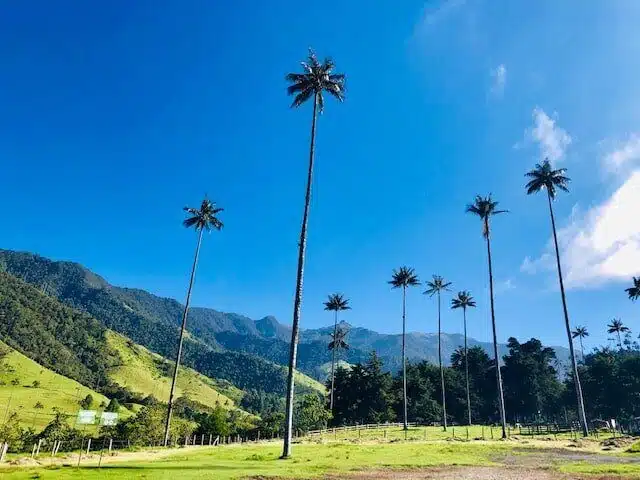
Those trees look like something straight out of Avatar! This hike in Salento seems like another of the best hikes in Colombia.
- Location: Salento, Colombia
- Distance: 12.4km
- Duration: 5 to 7 hours
- Difficulty: Moderate
The Cocora Valley (Valle de Cocora) hike is one of the top attractions in Colombia.
It’s a primary reason people visit the adorable small town of Salento nestled in the mountains of the Coffee Triangle (Eje Cafetero).
This epic hike features a lot of diversity including lush cloud forests (high-elevation rain forests), verdant valleys, and the slightly cartoonish wax palm trees.
It’s a solid moderate hike with one area of higher difficulty.
This hike is 7.7 miles and takes between 5 – 7 hours.
There is also a shorter in-and-out hike that takes around two hours and leads you directly to Bosque de las Palmas, where you can mingle with the wax palms.
Grab a bagged lunch from Brunch de Salento in town then take a “Willy” jeep from the town square in Salento to the Cocora Valley.
Most people begin the hike in the cloud forest (counter-clockwise loop). You have to pass 7 dodgy suspension bridges as you weave back and forth over a stream.
Be sure to stop at the Acaime hummingbird sanctuary to take a short break to enjoy the birds. They offer aguapanela caliente with cheese, a traditional Colombian hot drink made from melted and caramelized sugar cane.
The next leg of your trek is up to the Finca la Montaña, where you can find incredible views of the valley.
This is the most difficult part of the hike, climbing the steep switchbacks up this grassy slope. Hang in there and take your time, as the views from the top are well worth the climb.
Next, start on the sloping downhill walk on a wide dirt path to the area with the wax palms. Enjoy the views of the valley and hug a wax palm or two. They may be 200 feet tall but you can get your arms around them!
This hike is amazingly beautiful and the diversity it offers makes it a must-do when visiting Colombia.
There are a lot of great things to do in Salento including coffee plantation tours, horseback rides, and other hikes.
It’s a worthy respite from some of the large Colombian cities.
Contributed by Sam from My Flying Leap
Follow their adventures on Pinterest
Best South American Hikes Elsewhere on the Continent!
28. W or O Treks, Torres del Paine
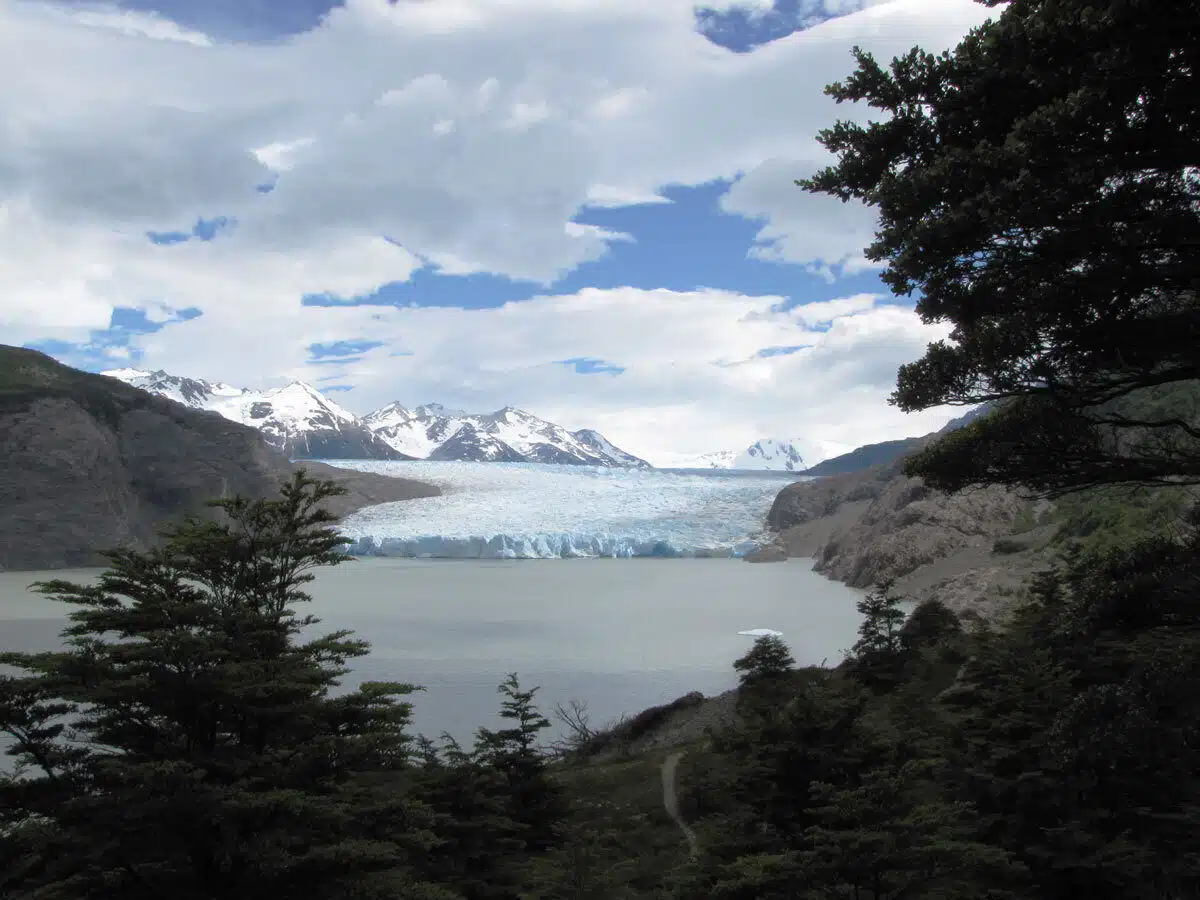
Views don’t get much more stunning than that. Thanks goes to Roger from Expert World Travel for sending this through.
- Location: Torres del Paine, Patagonia
- Distance: 80km or 110km
- Duration: 3 to 6 days or 10 days
- Difficulty: Moderate to Hard
If you are in Patagonia and want to do one of the most memorable hikes in South America, then the W or O treks in Torres del Paine are just for you.
Just to get this out of the way, the O trek is a full 10-day loop around the park and actually includes the W trek.
The W trek only covers the front part of the park, but many will argue that it includes the most spectacular sections.
In my opinion, that may be true, but the full 10-day loop has its own upsides including a far quieter hike and the chance to slowly build-up to the more mind-blowing views on the W trek.
If you have not heard of Torres del Paine before, it is in the Chilean part of Patagonia, on a former ranch, and includes spectacular views of craggy mountains, glaciers, and ice-blue lakes you will never forget.
The W Trek, the more commonly done one, is 3-6 days long, depending on how fast you hike or how much time you have.
It is moderately challenging, as you need to carry camping gear and food.
Although there are options to avoid both in some cases, as there are cabins along the way.
The O Trek is typically 10 days long and you will need to carry camping gear on this one and in most cases food. So, it is quite challenging, as your pack ends up being quite heavy.
Ours were 20kg (or around 44lbs).
Just keep in mind that Patagonia has very changeable, and windy weather so you need to be ready for anything. I recommend only doing this hike in the peak of summer as a result.
However, no matter when you decide to go, it is an epic hike you will never forget!
Contributed by Roger from Expert World Travel
Follow their adventures on Facebook
29. Volcano Villarrica Hike, Chile
- Location: Pucon, Chile
- Distance: 9.6km return
- Duration: 7 hours
- Difficulty: Moderate
Volcano Villarrica is one of the most active volcanoes of Chile, and resides in the city of Pucon in Southern Chile.
Residing about 30 km from the town of Pucon, Volcano Villarrica makes for a popular day hike for anyone visiting Chile.
But even though a lot of hikers love this trek, Volcano Villarrica hike is not an easy one. The steep icy and gravel volcano takes up about five hours to climb up.
First you will have to go through a rocky terrain, then soon you would make your way carefully through the snow-covered Villarrica.
One way of the hike is about 4.8 km in length.
The strong winds that blow on Villarrica makes you feel that you might be thrown off the mountain any moment.
But don’t you worry for you will be with experienced guides on this trek who would make sure that you use the right equipments and techniques to safely climb up.
When you get to the top huffing and puffing, the views are out of this world. You will see many other volcanoes in the distance which makes for the perfect backdrop.
Going down is the most fun part of the hike for you would be mostly sledging off on plastic boards until you reach the rocky part of the volcano again.
Descending also takes a couple of hours but it’s less strenuous.
Don’t miss this hike on your Chile trip for it’s definitely a challenging trek but one of the most adventurous things you will ever do in your life.
Contribution by Priyanka from On My Canvas.
Follow their adventure on Instagram
30. Quilotoa Loop, Ecuador
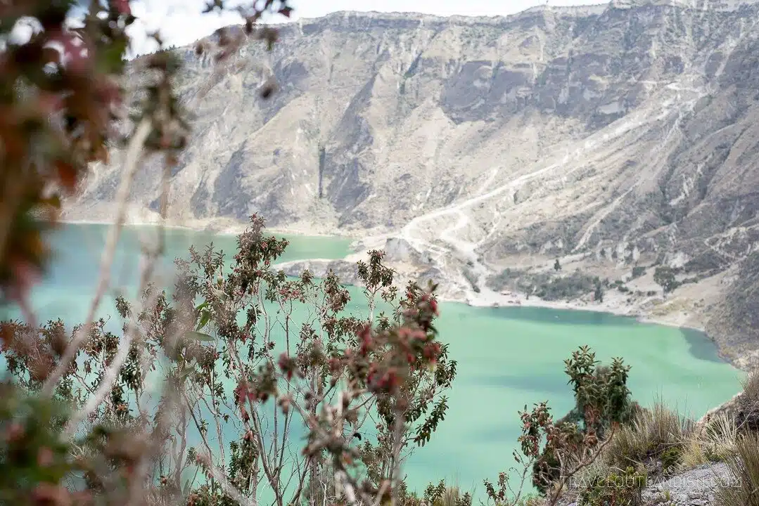
An awesome shot from the Quilotoa Loop, Ecuador.
- Location: Latacunga, Ecuador
- Distance: Varies by selection
- Duration: 4 Days
- Difficulty: Easy to Moderate
While Peru has peaks and Patagonia has grasslands, the best part of trekking in Ecuador are the crater lakes.
And Laguna Quilotoa – the 3km wide caldera turned brilliant green with minerals – is nothing short of a spectacular spot to finish the Quilotoa Loop.
There are some 200km of trails near Volcan Cotopaxi, but the Quilotoa Loop most commonly refers to the 2 – 4 days of hiking between Insinliví, Sigchos, Chugchilan, and Quilotoa.
The trail travels through agricultural areas and small villages where you’ll really get a sense of the Ecuadorian countryside.
And since you’re sleeping in local bed and breakfasts that offer full board (most often serving food plucked straight from the garden), you won’t have to carry much of anything on your back and you can just enjoy the journey.
Whichever route you take, I highly recommend finishing your trip at Laguna Quilotoa. While it’s possible to get to the lake on a day trip from Quito, it’s far more rewarding to come in from the other side.
Wandering around the crater rim in solitude is a grand, hard-earned finish to a few days of trekking.
Contributed by Taylor from Travel Outlandish
Follow their adventures on Facebook
The Best Hikes in North America
Let’s finish with a selection of the best hikes in North American. Check out these epic backpacking hikes in Canada and the US.
31. Acatenango Volcana, Guatemala
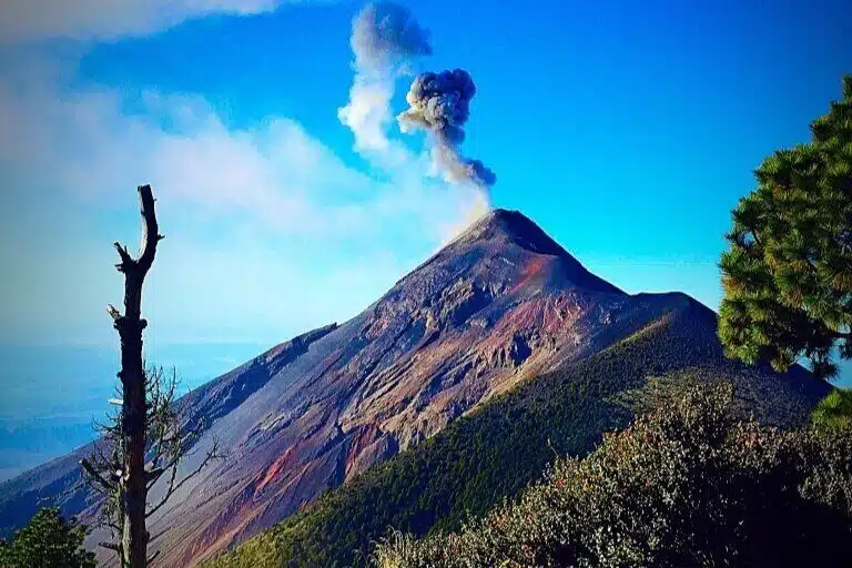
I’ve heard stories of this hike in Guatemala in the past. It’s another that sounds other worldly.
- Location: Guatemala
- Distance: 18km
- Duration: 12 hours (or divide into an overnight hike)
- Difficulty: Hard and Technical
Several volcanos make up the landscape of Antigua in Guatemala, but the most unique has to be Acatenango.
Whilst dormant, it is situated next to Fuego, the world’s most consistently erupting volcano, and hiking Acatenango lets you experience this active volcano from up close.
The 11 mile hike is tough due to the 1500m elevation gain to 3976m, but if you are short on time it can be done in one day, trekking from 5am until 5pm.
However, expect technical trails, slippery slopes, rock scrambling and steep terrain. For this reason, I suggest doing the overnight trip.
It breaks up the hike and allows you to camp just a stone’s throw away where you can fully experience the eruptions of Fuego (during the day you will not see sunset, sunrise or the orange lava).
For the overnight trip you start at 7am and hike 5 hours on the first day to the campsite, and can experience sunset and the night’s eruptions from here.
On the 2nd day, you hike 1-2 hours to the summit for sunrise and then have breakfast at camp before hiking 3 hours back down to the base.
You are usually back in Antigua around midday, with some unforgettable memories (and sore legs).
Contributed Roshni from The Wanderlust Within
Follow their adventures on Instagram
Best Hikes in Canada
32. Joffre Lakes
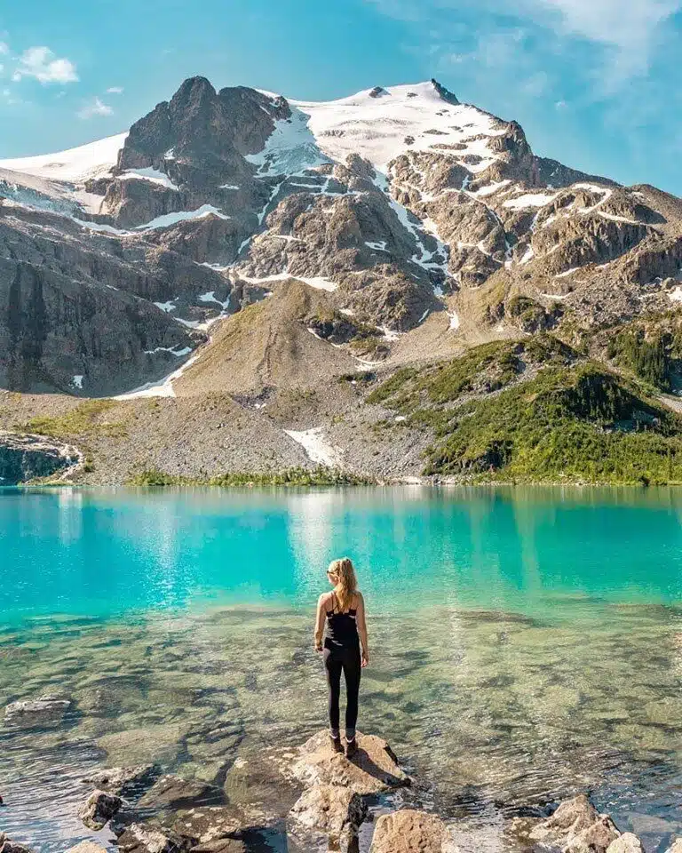
Canada’s another country renowned for its beauty. The Joffre lakes hike looks and sounds stunning.
- Location: Western Canada
- Distance: 10km
- Duration: 4 hours
- Difficulty: Easy
Joffre Lakes in Western Canada is by far one of the most beautiful hikes in Canada (if not the world!).
There are a few reasons this hike is particularly special and one everybody should do in their lifetime.
First of all, the hike is very accessible and easy for almost anyone to do. The hike is in Joffre Provincial Park about an hour drive from Whitler or about 2.5 hours from Vancouver!
And since the hike is only 10 kilometers long and takes the average person 4 hours to complete, it is one of the things you can do from Vancouver or Whitler on a day trip!
The hike is also amazingly beautiful.
There are three different lakes you will see, two along the way and then the lake one at the very end where you finish the hike and turn around.
The lakes are all bright blue in color with mountains as their backdrop – so gorgeous! Along the trail, you will also see a large waterfall and views of mountains the entire way.
The only downside to hiking Joffre Lakes is that it can get very busy in the summer months on holidays or weekends.
My best advice is to arrive early and start hiking well before 8 am (the earlier the better!) Also, avoid going on long weekends.
If you do this, it won’t be too busy and you’re sure to have a memorable experience.
Contributed by Bailey from Destinationless Travel
Follow their adventures on Instagram
33. The West Coast Trail
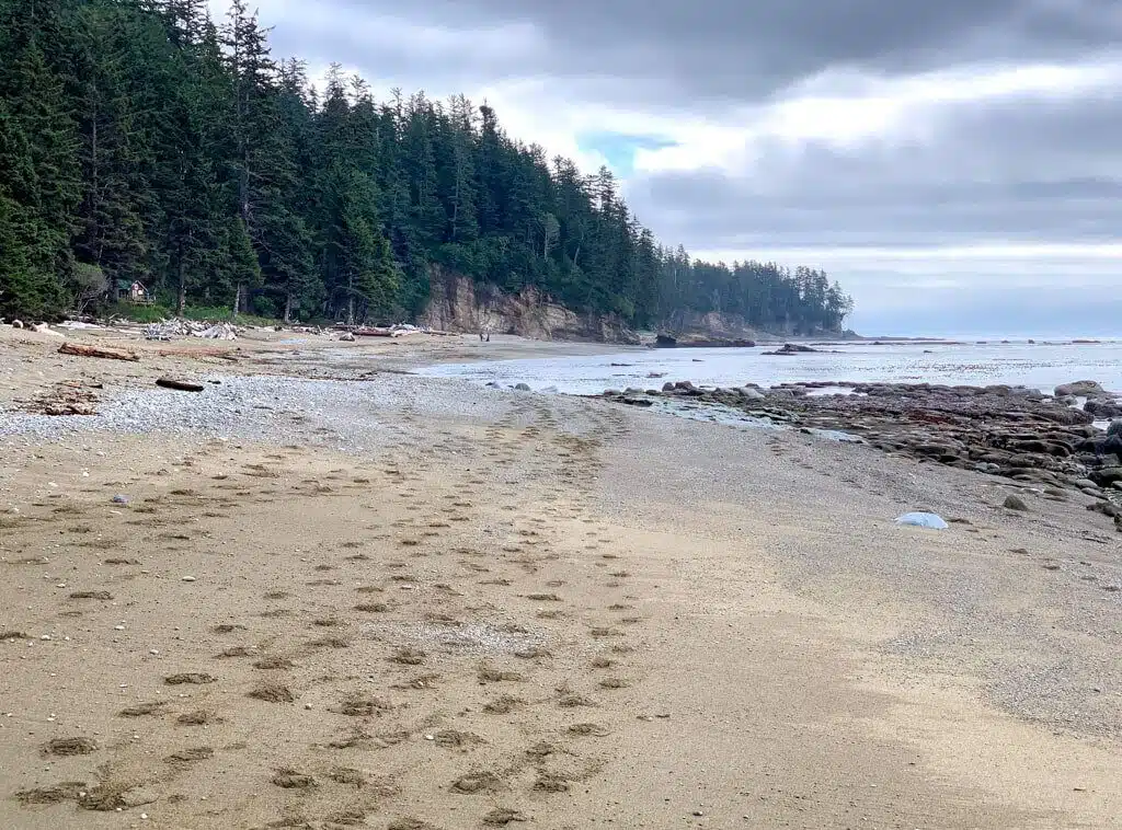
LIterally everything about the West Coast Trail sounds epic…apart from the Bears.
- Location: Vancouver Island, Canada
- Distance: 75km
- Duration: 6 to 7 days
- Difficulty: Hard and technical
The West Coast Trail is one of the most famous trails in Canada. It travels 75 kilometers along the wilderness coast of Vancouver Island in British Columbia.
It’s a challenging trail that takes most people 6 or 7 days to complete.
You need to reserve in advance, and permits are not cheap, but the stunning beauty of the coastal rainforest is worth it.
Sometimes the hike runs inland on rough trails through the rainforest, along slippery boardwalks or through muddy bogs.
At other times, it follows the coast, which can be sandy, rocky or covered in boulders and driftwood. Many of the creeks on the route have no bridges so you have to ford or use a hand-pulled cable car.
And those creeks are down at the bottom of steep canyons. To get down into the canyons (and back up again), hikers climb wooden ladders.
The West Coast trail travels between two remote coastal towns:
Port Renfrew and Bamfield.
You can hike the trail in either direction and there’s a shuttle bus service to both trailheads from the nearby city of Victoria.
There are wilderness campgrounds along the beach every few kilometers, each with their own toilet and bear-proof food storage locker.
It rains a lot in this part of the world so rain gear is essential. But when the sun comes out, it’s one of the most beautiful places to hike.
Contributed by Taryn from Happiest Outdoors
Follow their adventures on Instagram
Best Hikes in the United States
34. Sky Pond Trail
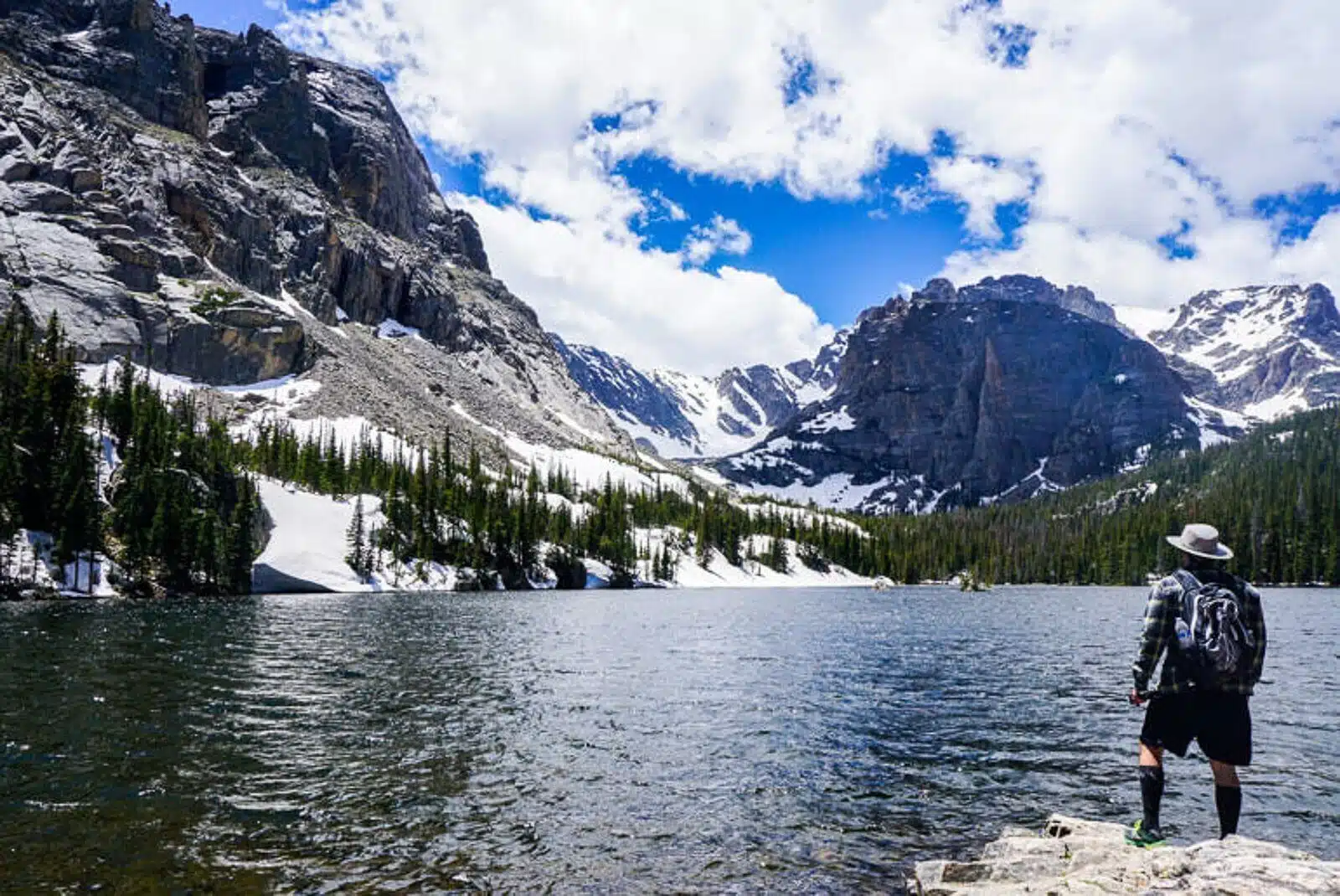
I love the descriptive name of this hike in the US. The views aren’t bad either!
- Location: Rocky Mountain National Park, Colorado, US
- Distance: 14km
- Duration: 5-7 hours
- Difficulty: Moderate
One of the best hikes in the entire world is the hike to Sky Pond in Rocky Mountain National Park.
The trail to Sky Pond is a 14 km round trip and can be completed in a day; it takes around 5-7 hours to complete.
Depending on your hiking abilities, the trail can be rather difficult or it can be fairly easy. The trail starts at the Glacier Gorge trailhead inside Rocky Mountain National Park.
The first part of the trail up until you pass Alberta Falls can be pretty crowded as it is fairly easy to get to Alberta Falls and the waterfall itself is pretty impressive.
After passing Alberta Falls the crowds lesson and you won’t pass many people for the rest of the hike. As the trail starts heading up, the views get more and more impressive.
At around the 2.8-mile mark, you will reach the “Loch” which is 1 or 3 alpine lakes you will pass on this hike.
The Loch is absolutely gorgeous and you start thinking that it couldn’t get any better than this, but it surely does!
After passing the Loch the trail starts winding next to a rushing river.
At just about the 4 mile mark you will come upon Timberland Falls- another pretty awesome waterfall that you will have to rock scramble up the side of to continue on the trail.
The views from the top of Timberland Falls are probably the best on the trail and there is another alpine lake waiting for you at the top!
After checking out the 2nd alpine lake the trail continues on through big boulders to Sky Pond, your final destination.
If you have a chance to hike this trail in Rocky Mountain National Park, we definitely recommend doing so!
Contributed by Jessica from Unearth the Voyage
Follow their adventures on Instagram
35. Cascade Canyon Hike
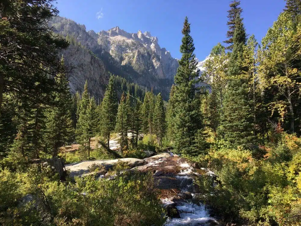
So much beauty in one photo- Cascade Canyon really does sound like one of the best hikes in the US.
- Location: Grand Teton National Park, Wyoming, US
- Distance: 14.5km
- Duration: 3 to 4 hours
- Difficulty: Moderate
Cascade Canyon is the highlight of Grand Teton National Park for me.
Not only is the scenery is breathtaking, but there is also a good chance of seeing wildlife.
The trailhead is actually about 3.2 km around the other side of Jenny Lake from the Visitors’ Center and parking lot.
If you want to avoid these extra km (6.4 km both ways), you can take a seasonal shuttle across Jenny Lake to the trailhead.
It’s an out and back trail, about 14.5 km in total from and back to the trailhead/ shuttle stop, so these extra 6.4kms are a lot.
The first 2.5 km of the trail are uphill and this is what earns it a moderate rating.
If you take it slow and take lots of photos like I did, it’s not too difficult.
At the top, your efforts are rewarded because this is when you enter the canyon, and the scenery from hereon in is stunning.
Craggy hills topped with a glacier frame the canyon. A river runs through the canyon and the rest of the trail is pretty flat, following the river for the most part.
I actually turned back at the cascade that gives the canyon its name, a little before the official turnaround point.
I took my time, stopped for lunch and also took the 1km spur trail to Inspiration Point and the 60-meter high Hidden falls on the way back, and the whole thing took me five hours.
It’s possible to see black bears, so take precautions.
I didn’t see any bears, but I did see several very cool river otters and a moose drinking in the river. Sightings like these aren’t guaranteed, of course, but are not uncommon in season.
The Cascade Canyon trail truly is a must-do hike when you are in Grand Teton National Park.
Contributed by James from Travel Collecting
Follow their adventures on Facebook
36. High Divide Trail to Seven Lakes Basin
Here’s another hike to get your leg’s burning and heart racing. Sounds like a top US hike to me.
- Location: Olympic National Park, Washington State, US
- Distance: 30.6 km
- Duration: 1 to 2 days
- Difficulty: Hard
One of the best backpacking trips in Washington State USA is the High Divide Trail located in Olympic National Park.
This hike features a waterfall, tall mountains, sapphire blue lakes, and beautiful wildflowers. It is on many people’s bucket list, and it should be on yours too!
This trail is 19 miles roundtrip with an elevation gain of 4000ft.
Which is why it is rated as difficult. Many people attempt to hike it in a day, but I recommend backpacking the trail for at least two days.
The elevation gain and the mileage is hard on the body, even for active people.
Keep in mind that you do need to get a permit for it if you want to go backpacking. They usually go on sale every March.
The trail is unique as it takes you through many different landscapes. At first, it starts off in the rainforest area where there are trees galore. You even pass by one of the most popular waterfalls in Washington: Sol Duc Falls.
Next, the trail takes you to a higher elevation.
The trees start to disappear and you are left walking on a ridge with mountain and lake views. The views are extraordinary, especially when you are hiking on the ridge.
Contributed by Michelle from The Wandering Queen
Follow their Adventures on Facebook
37. The Arctic Circle Trail, Greenland
Hiking in the Arctic Circle sounds like one long epic adventure.
- Location: Greenland
- Distance: 164km
- Duration: 9 days
- Difficulty: Moderate
On the west coast of Greenland, the world´s biggest island is one of the greatest hikes in the world, the 164km/102mile long Arctic Circle Trail, a hike that is fast becoming one of the most popular hikes in the northern part of the world.
You will need to be completely self-sufficient and carry all your food and camping gear along with you.
The chance of getting a fast rescue here is non-existent if you would be unlucky enough to have an accident along the trail.
The hike normally takes 9 days from the starting point at Kangerlussuaq to Greenland´s second-biggest city Sisimut on the west coast.
The hike is not difficult physically, but since you will have to carry absolutely all your food along with you, is it not a hike for the unexpected one.
If you are doing the hike will you be rewarded with pristine untouched nature and the chance of seeing reindeers and muskox along the trail.
Contributed by Christian from the Unusual Traveller
Follow their adventures on Instagram
38. Cathedral Rock
The famous red rock of Arizona! Here’s a brief description of what sounds like another awesome hike in the United States.
- Location: Sedona, Arizona, US
- Distance: 4.5km
- Duration: 1 to 2 hours
- Difficulty: Easy to Moderate
Cathedral Rock is a popular day hike in Sedona, Arizona.
The Cathedral Rock Trailhead is located 10 minutes outside of Sedona. The trail is 1.4 miles in and out and is classified as a moderate hike.
The hike starts off easy enough but the end is quite strenuous to get to the top. You will gain almost 5,000 feet in elevation on this hike.
Cathedral Rock is a natural sandstone butte on the Sedona skyline.
On this hike you will see the red rocks that this part of Arizona is known for.
The best time to do this hike is first thing in the morning. Arizona heat can be relentless so make sure you bring plenty of water and a hat for shade.
And of course enjoy the views!
Contributed by Nicole from American Southwest Obsessed
Follow their adventures on Instagram
Best Hikes in Hawaii
…Okay, so Hawaii’s part of the US, but these hikes deserve special mention so I decided to group them together separately!
39. Moana Falls
Lush rainforest in Hawaii on the way to Moana Falls. This sounds like an awesome Hawaii hike that anyone can do.
- Location: Honolulu, Oahu, Hawaii
- Distance: 2.5km
- Duration: 1-2 hours
- Difficulty: Easy – Intermediate
Hawaii has some of the best hikes in the world!
The Moana Falls Trail is part of the Honolulu Mauka Trail System consisting of 18 trails in the area. Moana Falls is located in the Moana Valley.
It leads up to a 150-foot waterfall. The trail to get to the waterfall takes you in the mountains of Koolau in a tropical rain forest.
Moana Falls has been used in several movies and television shows such as Jurassic Park, Catching Fire, Lost, and Hawaii 5-0.
The beauty is unreal and it is no surprise these movies chose to use this trail to film at.
We are avid trail runners and wanted to find the best trails in Hawaii while we were on vacation. As we researched the area, we found that Moana Falls was relatively close to Waikiki Beach.
We wanted a short morning run and this seemed like the perfect place. It did not disappoint!
This trail was so amazing and beautiful it stopped me in my tracks so many times because it is gorgeous (maybe not the best for trail running if you haven’t seen the beautiful sites before!).
The trail was also muddy as it rains frequently in this part of the rain-forest.
I didn’t mind one bit that I had to slow down and be a little careful on parts. It was by far the most beautiful hike on Oahu that we were able to see!
Parking:
Parking is located at the bottom of Moana Road.
The cost is $5. There is an attendant there during certain hours.
However, we are early risers and went at 6:30 am and there was no one on duty so if you want to avoid the cost go early!
Side Notes and Warnings:
The pool beneath the waterfall is not safe to swim in.
There is a threat of getting infected with leptospirosis which causes flu like symptoms for two weeks. The area near the falls is very muddy and slippery.
We did not venture to the top of the falls because we did not feel it was safe. Some hikers have fallen from the top.
If you avoid these two things you will be fine.
Contributed by Lisa from Planning Away
Follow their adventures on Facebook
40. Diamond Head Crater Lake
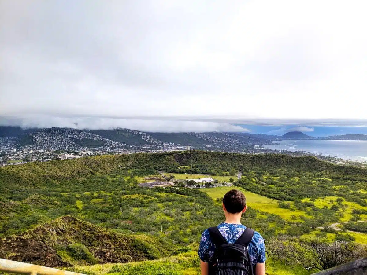
There’s so much to look at in this photo of the Diamond Head Crater Lake. Hiking to the lookout must be an incredible experience.
- Location: Oahu, Hawaii
- Distance: 2.25km
- Duration: 1 to 2 hours
- Difficulty: Easy
There are so many amazing hikes on Oahu, Hawaii that you will be spoiled for choice, but one of the most rewarding is Diamond Head Crater.
The crater was nicknamed Diamond Head by British sailors in the 1800s, who were mesmerised by the rocks on top that sparkled in the Hawaiian sunshine.
The hike will take you through a volcanic crater spanning an incredible 450 acres – so huge in fact you can see it from your sunbathing spot on Waikiki beach!
The hike itself is not particularly strenuous – in total it’s only 1.4 miles and the majority of it has marked paths with handrails.
As you reach the summit however, you will be treated to some rather claustrophobic narrow corridors and a spiral staircase within an old firehouse.
However, once you get through these, the panoramic vistas of the island are so worth it.
Note, take cash as there is a small entry fee of $1 per person for pedestrians or $5 for a car that goes towards the upkeep of the trail.
Diamond Head is open from 6am until 6pm and although we hiked it before 9am on a Monday morning it was still super busy, so expect queues at points.
Also be wary of a few enterprising locals who try and sell overpriced certificates at the top to mark the end of your hike.
It takes around 1.5 – 2 hours to complete the loop, depending how long you stop to admire the incredible views.
Contributed by Darren and Lauren from Faramagan
Follow their adventures on Instagram
Time to Wrap Up
I hope this list of the best backpacking hikes around the world has proved inspiring and insightful.
As you can tell, there’s a trail for everyone, no matter which country you find yourself in. Everywhere you go there are hiking and trekking options galore.
That’s sure to put a smile on the face of any backpacker or hiking enthusiast eager to escape the tourist trail and get out into nature.
I personally can’t wait to get stuck in and tick as many of these hikes off my hiking bucket list as possible! Which one sounds best to you?
Let me know in the comments!
Fancy reading more posts like this? Be sure to subscribe to the blog too (use the boxes below or in the sidebar!).
Great post! Lots of ideas for new places.
Thanks Chris! Glad you enjoyed it 🙂